|
||

|

|
|

|
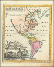
Nice example of the first state of Oretlius' map of America, from Ortelius' Theatrum Orbis Terrarum, the first modern atlas of the World..
Ortelius map of America is without doubt one of the most recognized and influential maps of America from the 16th Century. The map first appeared in the 1570 edition of Ortelius' Theatrum Orbis Terrarum. Over the next 42 years (plus an exceptionally rare edition of 1628), it went through three major revisions.
Ortelius depicts the discoveries of a number of explorers, but the general shape of America is derived from Gerard Mercator's 21 sheet werold map of 1569. The bulge in South America is the most notable feature of the map, which was not corrected until the third state. The cartouche hides the lack of knoweldge in the south Pacific, although the massive Terra Australis Incognita is still very much in evidence, a myth not disspelled until Cook's second voyage.
The West Coast of North America has a wildly inaccurate western projection. This first edition predates the appearance of the Chesapeake, which did not appear until the 3rd state. Also the Solomon Islands and Cape Mendocino and the name California are not added until the third edition.
The present example is a very early state of the highly sought after first edition of the map, which was followed by later editions of 1579 and 1587. The editions are easily identifed by the presence of the large bulge on the southwest coast of South America (eliminated in the 1587 edition) and the large ship in the Pacific sailing westward (the 1579 edition reverses the direction of this largest sailing ship. The earliest states of Ortelius' map of America can be distinguished (1570-1574) can be distinguished from the first edition, third state of the map, by appearance of the longitude grade number 230 on the top of the map, which was removed after 1574. The first edition also includes an irregular dot pattern off the southeast coast of South America, where there was apparently at one time a ship engraved in the Atlantic, but which was removed.
The color in this example of the map would appear to be old color. There are remnants of color offsetting around two smaller ships in the Pacific Ocean, which are tell tale signs of early color, but it is difficult to say with certainty as the color is generally muted and understated.
An essential map for American Collectors.
Abraham Ortelius is perhaps the best known and most frequently collected of all sixteenth-century mapmakers. Ortelius started his career as a map colorist. In 1547 he entered the Antwerp guild of St Luke as afsetter van Karten. His early career was as a business man, and most of his journeys before 1560, were for commercial purposes. In 1560, while traveling with Gerard Mercator to Trier, Lorraine, and Poitiers, he seems to have been attracted, largely by Mercator’s influence, towards a career as a scientific geographer. From that point forward, he devoted himself to the compilation of his Theatrum Orbis Terrarum (Theatre of the World), which would become the first modern atlas.
In 1564 he completed his “mappemonde", an eight-sheet map of the world. The only extant copy of this great map is in the library of the University of Basel. Ortelius also published a map of Egypt in 1565, a plan of Brittenburg Castle on the coast of the Netherlands, and a map of Asia, prior to 1570.
On May 20, 1570, Ortelius’ Theatrum Orbis Terrarum first appeared in an edition of 70 maps. By the time of his death in 1598, a total of 25 editions were published including editions in Latin, Italian, German, French, and Dutch. Later editions would also be issued in Spanish and English by Ortelius’ successors, Vrients and Plantin, the former adding a number of maps to the atlas, the final edition of which was issued in 1612. Most of the maps in Ortelius' Theatrum were drawn from the works of a number of other mapmakers from around the world; a list of 87 authors is given by Ortelius himself
In 1573, Ortelius published seventeen supplementary maps under the title of Additamentum Theatri Orbis Terrarum. In 1575 he was appointed geographer to the king of Spain, Philip II, on the recommendation of Arias Montanus, who vouched for his orthodoxy (his family, as early as 1535, had fallen under suspicion of Protestantism). In 1578 he laid the basis of a critical treatment of ancient geography with his Synonymia geographica (issued by the Plantin press at Antwerp and republished as Thesaurus geographicus in 1596). In 1584 he issued his Nomenclator Ptolemaicus, a Parergon (a series of maps illustrating ancient history, sacred and secular). Late in life, he also aided Welser in his edition of the Peutinger Table (1598).