|
||

|

|
|

|
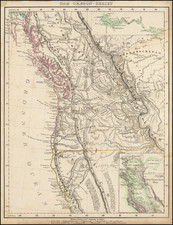
Nice full color example of Bruno Schmolder's extremely rare map showing his overland travels between St. Louis and the West Coast between 1843 to 1846.
The map provides a tremendously detailed look at the west, tracking Schmolder's route from St. Louis to Colorado, Salt Lake and the Lake Tahoe area to California and showing the Spanish Trail, Fremont's 1843 Route and several other important early western roads. The detail in the area of California, Oregon, Colorado, Utah, Nevada and Texas are of special note, with many early forts, Indian Tribes and other details noted. In California, the topographical detail id noteworthy, as is the meticulous account of the pre-Gold Rush settlements, missions, etc. In Texas, Fischer's Grant is noted.
In Colorado, Ft. Lancaster is shown (a trading post founded by Lancaster Lupton which existed only between 1837 and 1844), as is Fort John (originally constructed as a trading post named Fort William by Roger Campbell and William Sublette in 1834 and sold to a fur syndicate in 1835 and later to the American Fur Trading Company in 1835, then enlarged by John B. Sarpy in 1841, before being sold to the US Government in 849) also located, along with early details in the Rocky Mountains.
As noted by Wagner-Camp (155):
Bruno Schmolder traveled overland from Missouri to California in 1843, where he stayed for a while with John A. Sutter, and apparently worked out a scheme for the colonization of New Helvetia with German or Swiss immigrants. Schmolder returned to Germany in 1846 or early 1847, and prepared and published his book just before the announcement of the discovery of gold [in California].
The Soliday Catalogue description (Part B, #1262, 1945) notes:
Schmolder's work is one of the rarest [and most important early works] on the west, not only because of its factual information but because of its vast bibliographic appeal in as much as it relates to most all the states lying south of the Missouri and west of the Mississippi. Buck No. 442 fails to locate a complete copy, citing the title from Sabin and stating that "The Library of Congress has the first part, and the 'Anhang' to the second part." The Biblioteca Geographia, Leipzig, 1857, gives 1849 as the date of the First Edition. This copy has been carefully collated with copies in two of the largest private collections in America, from which the conclusion must be drawn that the three maps and plates (including the St. Louis view) must appear in any complete copy. Sabin refers to an 1848 edition, but none has ever been found and, moreover, the citation above from Biblioteca Geographia (published only 8 years after Schmolder's book appeared) would seem to refute Sabin.
Schmolder went overland to California in 1845, where he joined with Sutter and formed a partnership for the colonization of the region. He remained two years in the territory, returning to Germany in 1847. . . The work describes the journey to California and Oregon, the route, the prospective trading tation at San Francisco, and the establishment of a communal settlement at Sacramento.
Rarity
We have located only 2 complete examples of the book at auction in the past 70 years, Soliday (1945-$450.00) and Streeter (1968-$2,250).
![[Texas Coast] Partie Du Mexique Amer. Sep. No. 60.](https://storage.googleapis.com/raremaps/img/small/93536.jpg)
![[ Republic of Texas - Rare Early Variant ] Texas Compiled from the latest and best Authorities.](https://storage.googleapis.com/raremaps/img/small/96842.jpg)
![California [with large inset of Utah and Part of New Mexico]](https://storage.googleapis.com/raremaps/img/small/92004.jpg)