|
||

|

|
|

|
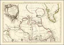
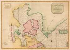
Highly important chart of Northeastern Canada, exhibiting Middleton's discoveries of the Hudson's Bay Company in 1742.
Christopher's Middleton's chart is "the first attempt at an accurate survey of the west coast of Hudson Bay . . ." and provides a remarkably detailed look at Hudson's Bay, Baffin Bay, James Bay, Hudson's Strait, Davis's Strait and the contiguous coastal regions, In addition to providing historical annotations of earlier discoveries dating back to Davis (1587), Baffin (1613, 1622 & 1624), and John Munk (1691), the map provides a marvelous account of Middleton's voyage in search of the Northwest Passage and his discoveries in Hudson's Bay in 1742. Middleton succinctly states his discoveries in the following annotation to the map:
The Parts discover'd in 142, lye between 64 degrees, 50 minutes and 67 degrees, 20 minutes: Lat: being Wager River, Repulse Bay, the New Straits with ye adjacent Lands, Inlets, Bays &c. --
For the further particular Observations of the Variation in these Parsts, the Reader may peruse Philosph: Transact. No.
NB. Principal Settlements that the Company now has in Hudson's Bay is Churchill River, York Fort, Fort Albany, Mouse River and Slude River.
The map notes the regions discovered by Middleton, along with his discovery of the wreck of a Danish ship, for which he states:
In this Bay John Monk tis said winter'd in the Year 1619, but I rather think it was in Churchill River from the Marks of a Wreck of a Danish Ship & some Brass & Copper Guns I took up in the Year 1722, with X.tian the 4th upon 'em dated 1610.
Middleton also includes details including magnetic variations, the flows of the currents, soundings and other navigational observations. With respect to the voyage, Seymour Schwartz illustrates the map (figure 34) and states:
Although the Hudson's Bay Company's charter mentions the quest for a passage to the Pacific and the Orient, it was essentially neglected by the Company, which was dedicated to the fur trade. In fact, the 1741-42 voyage of Captain Christopher Middleton grew out of the conviction of Arthur Dobbs, a member of the Irish House of Commons, who was convinced that the Hudson's Bay Company thwarted further exploration for a Northwest Passage in order to protect its commercial interests. Dobbs was able to entice Captain Middleton, one of the company's ship master, to conduct a voyage of exploration endorsed by King George II. . .
Middleton commanded an expedtion, consisting of two ships, that left England in June 1741 and wintered at The Hudson's Bay Company's Old Factory on the Churchill River, which enters Hudson Bay from the Southwest. During the following Summer, the ships sailed north and through Roe's Welcome Sound, between the west coast of Southampton Island and the Wager River. The ships proceded into a bay, the upper portion of which abutted the Arctic Circle. At that point, the ice packs thwarted progress north, leading to the assignment of the name "Repulse Bay." Middleton's expedtion proved that Welcome Sound was not an entrance into the Northwest Passage . . . The ships then returned to England. Dobbs initiated a campaign to discredit Middleton, and was convinced that Middleton deliberately failed to define a Northwest Passage, in order to maintain the monopoly of the Hudson's Bay Company.
The Mismapping of America (2003), pp 90-91. Schwartz goes on to note that it was not until Captain William Edward Parry's expedition in 1821-23, "that explorers laid to rest the concept of a westward pasage from [Hudson] Bay, thereby vindicating Captain Middleton, who had come to the same conclusion in 1742." ) p. 45. Middleton would later be presented with the Copley Medal by the Royal Society to whom he presented a paper on "The extraordinary degrees and surprising effects of Cold in Hudson's Bay".
Middleton's Chart of Hudson's Bay . . . is of the utmost rarity. The chart appeared at the Streeter Sale in 1969 (described as colored, and trimmed to the neatline, with some loss of image noted in a later cataloging by Sothebys in May 2004), having been purchased by Streeter from the legendary Americana dealer Henry Stevens in 1963. The May 2004 Sothebys entry (L04401-246), included the following description:
. . . Middleton, previously a captain in the employ of the Hudson Bay Company, was financed by Arthur Dobbs to explore the north-western extremities of Hudson Bay in search of a north-west passage. The expedition, from 1741-2, should have disproved notions of such a passage, but the increasingly delusional Dobbs convinced himself that Middleton had deliberately falsified his findings, and mounted an attack on the captain's integrity, using a series of rather dubious maps distorted to support his viewpoint.
Middleton's chart, published before the eruption of the controversy, is of great importance as the first attempt at an accurate survey of the west coast of Hudson Bay (Cumming et al, Exploration of North America, p.188), and the only reliable printed cartographic record of the captain's discoveries. Surprisingly, the chart was not included in Middleton's book defending his reputation, and is now rare.
While a bit soiled, the present wide-margined example is an exceptional survival for a separately issued map of such rarity. OCLC locates 3 examples in US Institutional Collections (University of Illinois, University of Michigan, University of Minnesota). We did not observe copies in the collections of the Library of Congress, Yale or John Carter Brown, Bancroft, or New York Public Library, among other major US Institutional map collections.