|
||

|

|
|

|
Stock# 25308
Description
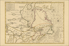
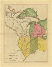
Fine example of the German edition of Perrin du Lac's seminal map of the course of the Missouri River.
As noted by Wagner-Camp,
Wagner states that the map . . "is the earliest published map of the trans-Missisisppi region which can be said to display even the faintest resemblance to accuracy." It shows the tracks of James MacKay (Jacques Machey) to the badlands of western Nebraska in 1796, and from this it can be assumed that a manuscript map of Mackay's (one is known to have existed at the time) became one of Perrin du Lac's sources.
Perrin du Lac describes a trading expedition up the Missouri to the Riviere Blanche (the White River in South Dakota) that left Saint Louis on May 18, 1802, and returned on September 20, 1802. He continues with a long note about the Missouri fur trade and an extensive discussion of the Indians of the Upper Missouri, including the Mandans, Sioux, Gros Ventres, and Cheyennes.
Reference
Wagner Camp 3:4