|
||

|

|
|

|
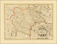
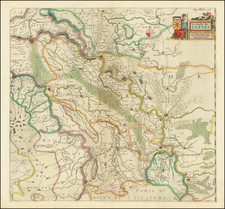
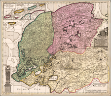
Striking large format River map of the Thieler Waard, showing the region along the Merwede River, from Gorinchem to Thiel, on the border between Noord-Holland and Brabant, just east of Dordrecht and Rotterdam. The map is centered on Zaltbommel.
The map is presented in a cadastral style, identifying towns, land owners, canals and the location of buildings, and windmills, among other features. It shows the details of the region, referencing the surveys of the region done by Wouter Leempoel in 1699 and H. Tas in 1729 (as the writer of this description does not speak Dutch, clarification of the title would be appreciated).
Includes the coats of arms of Bartholt Baron van Haeften, M.J. Baroness Pynsen van der Aa, Willem Hendrik Baron Pieck, Alexander Gisbert Baron Van Tengnagel, Diderick Johan Baron van Heereman, Simon Van Der Stel, F.C. Baron Van Aerssen Van Sommelsdyck, Reiner Baron Van Haeften, Jan Walraven Baron De Cock VanHaeft, Theordor Lam Boesburg, Adriaen Jan Baron van Borssel, Cornelis Baron Van Aersen, van F.S.C. Baron van Randwyk, J.J. Timmers, H. van Bracht, H. van Aylva, C. Dutry, J. Verploegh, Adolphus Bierman, J.N. van den Steen and O. van Byland.
The full title of the map is: Deze landkaart van den Thieler Waard, naar een tekening in 't groot ontworpen, door den landmeeter Wouter Leempoel, in den jaare 1699; met daar in gevoegde geprojecteerde dwars-dijken, ter gelegenheid der zeven beruchte doorbraaken in den Dalemschen Dyk, in den jaare 1729, door den landmeeter H. Tas nu verkleint, als mede door nodige veranderingen, naar de tegenswoordige gesteldheid des lands.
The map is very rare. A complete copy is noted in Rotterdam and a the western sheet in Delft.
![[ Rotterdam ] Roterodamum, Hollandiae in ostio Roteri Flu Opp. Magni il:lius Desiderij Erasmi Patria](https://storage.googleapis.com/raremaps/img/small/96869.jpg)