This item has been sold, but you can enter your email address to be notified if another example becomes available.


|
||

|

|
|

|
Stock# 25023
Description
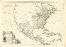
Decorative and highly detailed map from Garnier's rare and highly sought after Atlas Spheroidial…, published in Paris in 1860.
Garnier's maps are prized for their fine colors and precise details. The map shows the boundaries of the US immediately prior to Texas claiming its independence. Large NW Territory, Sioux Territory, Mandan Territory, Osage Territory, and Ozark Territory. Nice detail in Texas, including notes regarding its history as part of Mexico until 1837 and then Annexed into the US in 1845. Many Indian Tribes and early forts noted. Insets of Texas and St. Pierre Miquelon.
![A Geographical Chart: or, A Scheme, Comprehending The Most Important Particulars Relative To The Geography of North and South-America. : Designed to be an Auxiliary to the Student. Carefully Compiled from the Best authorities, by Amos Bingham [Copy-Right Secured]](https://storage.googleapis.com/raremaps/img/small/41406.jpg)
![[ Early United States Map ] Carte Des Etats-Unis De L'Amerique Septentrionale, dresse d'apres des Cartes Anglaises…](https://storage.googleapis.com/raremaps/img/small/39783.jpg)

![[United States Independence After The Revolution] A New Map of North America, with the West India Islands, Divided according to the Preliminary Articles of Peace, Signed at Versailles, 20 Jan. 1783, wherein are particularly Distinguished The United States, and the Several Provinces, Governments &ca, which Compose the British Dominions . . . 1783](https://storage.googleapis.com/raremaps/img/small/70734.jpg)
![[Shows Republic of Texas] United States and Texas](https://storage.googleapis.com/raremaps/img/small/101139.jpg)