


|
||

|

|
|

|
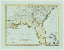
Early edition of this scarce pocket map of the Carolinas and Georgia, published by Anthony Finley.
The Eastern Georgia counties include regions of the Cherokee and Lower Creek Indians and a number of early forts. Includes a large table with topographical tables. Hand colored by counties and showing towns, roads, rivers, lakes, mountains and other geographical and topogaphical details.
The map includes the inscription of its first owner, Walter Terrell (born 1805 in Carolina County, Virginia). On several places on the verso,Terrell signs his name and in one case, notes: Walter Terrell Mount Carmel Wabash County, Illinois. October 16th 1829. Terrell is known to have left Hanover County, Virginia in 1829, He made a tour through the south by horseback. From Louisiana, he traveled up Mississippi Valley, finally stopping at the Grand Rapids of the Wabash in Illinois. There he remained for some time, engaged in land surveying, civil engineering, and teaching school. In 1836, Terrell was appointed Senior Assistant Engineer in the Southern Engineering District of Illinois. His work on the Illinois and Michigan Canal and other internal improvements centered on Alton, Mt. Carmel, and Shawneetown, Illinois. In 1838 he made a tour on foot through the Territories of Iowa and Wisconsin, and for a short period he traveled in the South, before settling in Iowa, where he procured a charter to erect,a dam upon the Iowa river. In the following year he returned to Louisiana and having closed his business there he returned to Iowa City in 1843 and built a flour mill.
The following is an excerpt of an article about Terrell, Connections on the Underground Railroad: A Salem Iowa and Iowa City Line: The Story of A Pioneer Quaker Miller In Iowa, by Lewis D. Savage ( www.icelandichorse.info/walterterrelliowacitymiller.html )
Walter Terrell as a young man was employed by Walter Crew the owner of Crewsville Farm and Mills in Hanover County Virginia. Walter Crew had two mills on his farm, the Auburn Mill, a three story stone mill on the South Anna River, and the Taylor's Creek Mill, a three story frame mill on Taylor's Creek. Both mills were equipped for grinding grain, sawing lumber and had blacksmith shops. They also had groceries, yard goods and Postal Service. In addition to learning the milling trade and operation Walter Terrell served as principal of the Washington Henry Academy in Hanover County in the late 1820's.
In 1838 [Terrell] toured the Territories of Wisconsin and Iowa on foot. He applied for and in 1840 was granted the right to build, within 3 years, a dam across the Iowa River near Iowa City by the Territorial Assembly. After receiving this authorization to build the dam Walter Terrell journeyed down the Mississippi River to Louisiana.
Walter Terrell returned to Iowa City in time to complete the dam across the Iowa River in 1843, and had his three story mill constructed and in operation in 1844. The Terrell Mill was equipped with six runs (top and bottom) of millstones which were powered by an undershot water wheel. The mill could grind 300 bushels of grain a day, and was equipped to bolt the flour. In a short time a wool-carding machine was added. . . .
Walter Crew settled his family on a farm outside of Salem also maintaining a close contact with his family in Iowa City. While there is not direct reference to running the underground railroad, there was frequent correspondence and visiting between Salem and Iowa City by the Crews with their daughters and son-in-law. Crew family letters tell of traveling with oxen to Iowa City by the Crews to visit their daughters and the mill. While it would seem that the Terrell Mill was on the line of the underground railroad and with the Crews in sympathy, likely the business of the underground railroad was at least conducted this way.
"Father has received your letters, and he requested me to write to sister, Sarah, and say to her that as regards her removal he sees no objection to it whether she will settle in a community purely Quaker, that he would advise her if she moved to settle among Quakers."
-Letter from Izard B Rice to Walter and Sarah Bacon Rice Crew, written 3-13-1847 from South Island plantation Charlotte Co. Va. The letter is written by Izard for his father, William Rice an elderly man about one year before his death.
"I have no doubt but that you have acted prudently, and wisely in determining to go where slavery does not exist amongst members of your own Society."
-Letter from Izard B.Rice to his brother -in-law, Walter Crew 1-8-1849
Anthony Finley (1784-1836) was an American map publisher. Little is known about his life. He is presumed to have been born in Philadelphia, where he also died. A publisher, Finley was also involved in several Philadelphia civic and professional societies such as the Philadelphia Apprentices’ Library. He may have been in business as early as 1809 and his first publication dates from ca. 1811.
His first maps also date from this year, with two maps in Daniel Edward Clarke’s Travels in Various Countries of Europe, Asia, and Africa. The first atlas published by Finley appeared in 1818, the Atlas classica, or, Select maps of ancient geography, both sacred and profane, for the use of colleges and schools in the United States. He is best known for his A New General Atlas Comprising a Complete Set of Maps (1824), which was a bestseller. There were two editions in 1824, with annual editions until 1834.
Finley was part of the first generation of American publishers who produced high quality, precise maps on American soil. He was in competition with other Philadelphia publishers, for example Henry S. Tanner. Finley’s A New American Atlas Designed Principally to Illustrate the Geography of the United States of America (1826) closely mirrors Tanner’s A New American Atlas Containing Maps of the Several States of the North American Union, with similar groupings of maps; the main difference is the smaller scale of Finley’s maps. Finley printed two editions of this atlas.


![A Topographical Description of Such Parts of North America as are Contained in the (Annexed) Map of Middle British Colonies, &c. in North America [with map:] A Map of the Middle British Colonies in North America. First published by Mr. Lewis Evans ... in 1755; and since Corrected and Improved, as also extended with the addition of New England, and bordering parts of Canada; from actual surveys ... by T. Pownall](https://storage.googleapis.com/raremaps/img/small/100077.jpg)

