|
||

|

|
|

|
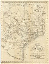
Detailed map of Texas, colored by counties, w an inset of Galveston area and Northern Texas.
The western counties are still largely incomplete. The map is rich with Indian notes, roads, early Texas rail line information, including railroads in existence and those in progress, notes on the Rio Grande and its trade prospects as a navigable river and Grand Indian Crossing, census info, notes regarding wild horses and cattle, early Indian routes, forts and a host of other early details. Includes large inset of Galveston. Shows roads, with distances, and some fascinating details in Northern Texas and the Comanche Trail, and the Marcy's Route to Donna Anna through Plantation Hill Ft. Ft. Worth & Dallas both shown.
This separately issued copy was originally issued as a pocket map, but the folder is now lacking. Signed several times by H.L. Hardegree and dated March 26, 1857.