|
||

|

|
|

|
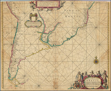
Rare first edition of the first English map of the Pacific Ocean. California is shown as and island. Abel Tasman's discovery of States Land (New Zealand) in 1642 is noted, with 9 place names including 3 Kings Island, Sand Hills and Steep Point noted. To the West, Anthony Van Diemen's Land is shown with 8 place names. Japan, The Land of Eso and Companies Land are shown, as are the Ladrones and a projection of Nova Guinea which foretells its being shown as attached to Austraila. The islands discovered by Hernand Galego in 1576 appear, as do many other islands in the South Pacific. Nice detail along the west Coast, from Fretum Anian to the Straits of Magellan. San Diego, P. Sir Francis Drake, Santa Barbara, Catalina, Mendocino and Monte Rey are all named. The Gulf Coast, and the Southeastern US are also shown, extending to Port Royal and naming C May, C Francis, Augustin B, Florida, B. Tompa (Tampa) and B. Joseph, etc. While Seller was known to have based some of his work on Goos, this map appears to loosely derive from Jansson's map of 1650, although many features (California, Companies Land, Tierra Del Fuego) are substantially updated and revised, and Jansson had no coverage of the Gulf Coast or East Coast, making the map unique in its coverage. No listing in a dealer or auction catalogue in the past 25 years. Full original color, uniform toning, w/ minor loss in upper corners, just touching image, but a nice example of this rare map. McLaughlin 58; Wagner 410, Tooley 39, Leighly 66.
John Seller was one of the most notable map and instrument makers in England in the late-seventeenth century. He was especially known for the sea charts, many of which featured in his influential English Pilot and Atlas Maritimus. Seller was born in London in 1632. His father was a cordwainer and John was apprenticed to Edward Lowe, of the Merchant Taylors’ Company. He was made free of that company in 1654. Later, he also was made a brother of the Clockmakers’ Company, which housed several instrument makers. He started business as a compass maker but expanded his offering to include navigational instruments and charts.
Seller’s career was halted temporarily, and fantastically, when he was tried for high treason in 1662. He was accused of involvement in a plot led by Thomas Tonge. While Seller likely only unwisely repeated rumors, he was convicted. The other conspirators, who did admit some degree of guilt, were executed, but Seller maintained his innocence and, via insistent petitions, he eventually secured his release from Newgate Prison.
This episode did not seem to slow Seller’s rise too much, however. Seller was granted a royal license to publish English-language maritime atlases. This gave him a near-monopoly and led to his being named hydrographer to the King in 1671. Although the point of the project was to produce English charts of Dutch dominance and bias, Seller ended up using many Dutch plates as his base material. The first volume of The English Pilot was published in 1671, followed by more volumes as well as The Coating Pilot (1672) and the Atlas Maritimus (1675). Seller was commercially successful, but some of his projects required further support. The English Pilot was eventually taken over by John Thornton and William Fisher, for example, and his proposed English atlas only produced maps of six counties.
Seller’s sons, John and Jeremiah, followed in their father’s profession. Seller also apprenticed several promising young men, including Charles Price, with whom his sons partnered. Through Price, Seller can be seen as the founding figure of an important group of London mapmakers that included Price, John Senex, Emanuel Bowen, Thomas Kitchin, and Thomas Jefferys.
![(Mexican War) [ Proposed United States - Mexico Military Border - January 1848 ]](https://storage.googleapis.com/raremaps/img/small/99246.jpg)