|
||

|

|
|

|
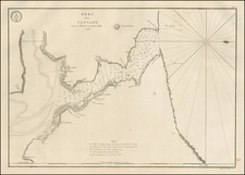
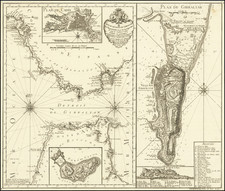
Unrecorded plan of the town, harbor and fortifcations at Mahon, on the island of Menorca.
InterestingpPlan of the City and Harbor of Mahon shows the fortifications constructed by the British through 1756. The map is exceptionally rare and was unknown to Ashley Baynton-Williams at the time of his publication of his on-line article Separate Printed Maps Of Mahon Harbour and St. Phillip's Castle 1700-1786. As noted by Baynton-Williams:
The British first gained control of Minorca in 1708, during the War of the Spanish Succession, and held the island until 1756, when it was captured by the French, during the Seven Years War. As part of the territorial settlement ending that war, in 1762, the island was restored to the British, and retained until 1782, when a joint Franco-Spanish expedition forced the capitulation of St. Philip's Castle, as one part of the European theatre of the American War of Independence. However, the British re-captured the island in 1788, before finally ceding the island to Spain in 1802.
The chief impetus for the mapping of the island during the eighteenth century was military, and a large number of maps were published throughout Europe, but particularly in England, France and Germany to depict both the fortifications prefatory to attack, and to record events of the sieges.
St. Philip's Castle also attracted a great deal of attention, and a series of plans of the castle's defences were prepared in 1756, at a time when they were in considerable disrepair. The British subsequently spent a great deal of money fortifying the castle, and extending the network of underground tunnels and defences, making the most expensive capital project undertaken by the British Army until the 20th Century.
This highly detailed plan, which was apparently published in Italy, has been printed on mid-18th century paper with an elegant fleur d'Iis watermark. While the map's style is somewhat crude, it reflects the completion of the fortifications constructed by the English and retains at least some of the names which the English gave to the various fortifications and provides a detailed, if somewhat free hand look at the harbor.