|
||

|

|
|

|
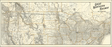
Marvelous panoramic map of the region between the Mississippi River and the Great Salt Lake, illustrating the overland trek of the Mormons in 1846 and 1847, which is drawn from Orson' Pratt's record of the trip.
Striking panoramic depiction of the mormon settlers routte west from Illinois to Utah, 1846-1847. Seeking to escape harassment, the Mormons left their embattled settlement in Nauvoo, Illinois, in 1846, reaching their destination in the Valley of the Great Salt Lake a year later. This map charts the Saints progress across the midwest and plains with four vignettes showing a wagon train, a group of tepees, a buffalo herd, and numerous other scenes from the journey.. Each campsite along the route is noted with the dates which the emigrant party stayed at each site.
A remarkable depiction of one of the great episodes in American history, produced to commemorate the 50th anniversary of the journey. The view is very rare. Ther is also as smaller version of the map, published by the Wilson Hotel (27 x 8 inches) in 1899.

![[ Used by '49ers To Travel To California ] Map of Oregon and Upper California from the surveys of John Charles Fremont and others authorities drawn by Charles Preuss 1848](https://storage.googleapis.com/raremaps/img/small/100557.jpg)
![Fly to a Holiday on Continental [Golden Jet Souvenir Flight Map]](https://storage.googleapis.com/raremaps/img/small/90328.jpg)

![History of the Expedition under the Command of Captains Lewis and Clark, to the Sources of the Missouri Thence across the Rocky Mountains and Down the River Columbia to the Pacific Ocean, Performed During the Years 1804-5-6 [with map:] Map of Lewis and Clark's Track, Across the Western Portion of North America from the Mississippi to the Pacific Ocean](https://storage.googleapis.com/raremaps/img/small/92506.jpg)