|
||

|

|
|

|
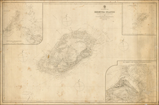
Fine example of William Heather's highly detailed chart of Jamaica, with inset maps of the harbors of Savanna, Portland Point, Kingstonand Morant Bay.
The map is divided into three counties (Cornwall, Middlesex and Surry), each of which is in turn divided by Parishes. The chart includes topographical detail, roads, rivers, mountains, towns, bays, islands, soudings and many other details. There are also Churches, Barracks and other details noted.
is map are Bibliographia jamaicensis; a list of Jamaica books and pamphlets, magazine articles, newspapers, and maps, most of which are in the library of the Institute of Jamaica (Map 42b.) and Catalogue of Books Illustrating the Principal Navigations, Voyages and Discoveries in Aemrica . . . And Topography of America Together with an Important Collection of Curious Maps . . . Edward Nield (Catalogue No. 18 (#267).
A later map withthe same title was issued in Norie's The Complete West India Pilot, drawn by W. Heather & J.W. Norie, and engraved by Stephenson, which included the same 4 insets.
William Heather is among the most important English Sea Chart publishers of the 18th Century. Heather began his business in 1765 as a publisher and dealer of sea charts and nautical instruments near the offices of the East India Company, under the sign of the "Little Midshipman," where he succeeded Mount & Page. The business was later to become known as "the Naval Academy" and "Navigation Warehouse," and was referenced by Charles Dickens in Dombey and Son. In 1768, the business became "Heather & Williams" and remained so until about 1812, when John William Norie, who had joined Heather in 1797 at age 25 and worked in the shop thereafter, became the proprietor.
![[ Virigin Islands to Trinidad and Tobago ] A Chart of the Antilles, or, Charibbee or, Caribs Islands, with the Virgin Isles . . . MDCCLXXXIV](https://storage.googleapis.com/raremaps/img/small/103660.jpg)
![[Martinique, Guadaloupe, Dominica and Marie Galante] . Suite des Isles Antilles 2. Partie](https://storage.googleapis.com/raremaps/img/small/81614.jpg)
![Amer. Sep. No. 69. Porto-Rico [and the Virgin Islands]](https://storage.googleapis.com/raremaps/img/small/42102.jpg)