


|
||

|

|
|

|
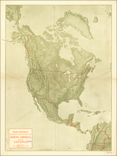
Extremely rare map of North America, the last such map to show the Bay of the West (Mar D'Uest), as set forth in a soon to be released book cataloguing maps showing the Bay of the West.
The Bay of the West first appeared briefly on French maps at the end of the 17th Century. The concept derived from manuscript maps prepared by Guillaume De L'Isle, although De L'Isle never published a printed map depicting this configuration. The earliest printed map to show the Bay of the West was Jean Baptiste Nolin's Le Globe Terrestre / Represente en Deux Plans-Hemispheres, published in Paris in 1700.
The present map is a marvelous end point to the myth, celarnly depicting the Bay of the West in a grand format and showing a northwest passage by narrow River, refered to as "Los Reyes F." and "F. Permenter."
Perhaps most intriguing is that the map was published in 1810, 4 years after the return of Lewis & Clark. Certainly, the map was inconsistent with the results of the Expedition, but demonstrates the resiliency of the best cartographic myths.

![[Hand Drawn Map] Le Golfe de Mexique avec les Pays Circonvoisins](https://storage.googleapis.com/raremaps/img/small/91580.jpg)