|
||

|

|
|

|
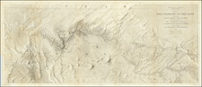
The earliest obtainable birdseye view of Georgetown, Colorado Territory, at the beginning of the Colorado Silver boom and the birth of Georgetown.
The map is oriented with the southeast at the top and tracks the Argentine Road past Leavenworth Mountain from the south, along a branch of Clear Creek. The map shows Georgetown only 10 years after the initial discovery of silver, the first major silver strike in Colorado.
The map offers a remarkable early graphical depiction of Georgetown's earliest days following the discovery of silver in the region. Silver was first discovered in the Georgetown area in 1864. As noted by Fossett, "In the fall of 1864, Gov. Steele, J. Hough and Mr. Pine, having some faith in the existence of silver . . . left Empire, and after camping at Georgetown started up the south fork of the creek [where they discovered the first silver]." Gov. Steele was undoubtly Robert Williamson Steele, Governor of the locally formed Jefferson Territory, which preceded Colorado Territory. Steele served as Governor of Jefferson Territory from November 1859 to June 1861. The U.S. Congress created Colorado Territory in February 1861 and the new Gov. William Gilpin arrived in Denver in early June. When Gilpin, arrived, Steele issued a proclamation dated June 6, 1861 disbanding Jefferson Territory and thus abolishing his own Governorship.
The first prospectors began coming to the area around Georgetown in 1865 (including Caleb Stowell, whose name appears on the map). Fossett notes that in the fall of 1865, M. P. Parker and John Cree had located the Henry Ward Beecher, New Boston, and other veins, on Democrat mountain above Georgetown. These veins are two of the veins which appear on the present map below Silver Mountain, which is clearly the Democrat Mountain referenced by Fossett. The New Boston vein would apparently go on to be one of the major veins in the area and apparently the major asset of the Green Mountain Silver Mining Company and later the Burlington Silver Mining Company.
According to Bancroft (p 591), "In 1867, [Georgetown and neighboring Elizabeth Town] was re-surveyed and platted by Charles Hoyt, under the direction of the citizens, and the name changed to Georgetown [merging the two settlements], by vote at a mass meeting held at the corner of Rose and Mary Streets. At the general election of this year, [Georgetown] became the county seat, and was incorporated in January 1868."
The view is rare, with Rep locating only 3 examples.
Eli Sheldon Glover (1844-1920) was one of the great viewmakers of the golden age of American bird's eye views. He began his career working for Albert Ruger in Ypsilanti, Michigan in 1866. He was primarily a sales agent for Ruger but probably also helped him in the actual production of city views. Two years later Glover went to Chicago to become a printer and publisher under his own name, but his Merchants Lithographing Company was shortlived; it was destroyed by the 1871 Chicago Fire after only three years of operation. The Great Fire caused Glover to look farther afield, and he began making views in Ontario and Kansas. Slowly he made his way west, producing Colorado views in 1873-'74. In 1874, while based in Salt Lake City he traveled the Rocky Mountains and produced views in Montana, Utah, and Wyoming. In 1876 and '77, the Glovers lived in Los Angeles and Eli produced a total of 16 views of California cities. In the last period of his active career, he focused on views in Oregon, Washington, and British Columbia. His second to last view was in Alabama, and his final view, in 1912 after a long hiatus, was Port Arthur, Texas.