|
||

|

|
|

|
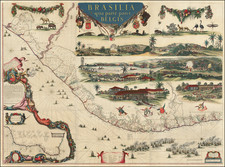
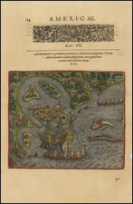
Rare early map of Bahia de los Todos Santos, Brazil, and inset plan of "Cidado do Salvador" by Henricus Hondius.
The plan depicts the taking of Salvador and the neighboring regions by the Dutch in 1624. As noted by Johannes Keuning ( Imago Mundi, Vol. 6, (1949), pp. 48-66):
The first great enterprise of the West India Company was the dispatching of a fleet of 26 ships in Dec. 1623 under the control of the admiral, Jacob Willekens and the vice-admiral Pieter Pietersz. Heyn. The intention was the conquest of San Salvador, at the Bahia de todos os Santos. This intention was completely attained in five days. Of this memorable act an engraving appeared in the same year. It is a picture of the Bahia de todos os Santos in Brasil and a view of the town S. Salvador, situated on the top of the mount on the bay; in the bay lies the whole Dutch fleet. The inscription reads: 't Amsterdam by Claes J. Visscher en Hessel Gerritsz. Underneath is a text in three columns: "Beschryvinghe Van't in-nemen van de Stadt Salvador in Brasil, door den E. Admirael lacob Willekes" by Hessel Gerritsz derived from an original report by the admiral himself.
During the same period, Gerritsz and Claes Jansz Visscher also prepared a similar map of the harbor, which seems to also include 26 ships.
The Portuguese settled Salvador in the mid-16th Century and the City quickly rose to become the capital of the region and the most important seaport and financial center in the region. The town was sacked and taken as part of a Dutch invasion in 1624, before being retaken by the Portuguese the following year. The Dutch again attacked Salvador in 1627. Following this attack, Gerritsz prepared several new maps and illustrations of the invasion.
This map was published in the "extremely rare work" (Schilder, Monumenta Cartographica Volume IX, p 479) entitled Description et breve declaration des Regles Generales de la Fortification published by Henricus Hondius in The Hague. This map ultimately derives from a large manuscript chart of All Saints Bay from c. 1624 currently held by the British Library that was evidently executed on the spot by a Dutch observer.
Henricus Hondius (1597-1651) was a Dutch engraver and mapmaker, a member of a prominent cartographic family. His father, Jodocus Hondius, was also an engraver and geographer. While working with his father, Henricus was instrumental in the expansion and republishing of Mercator’s atlas, first published in 1595 and republished by Hondius in 1606.
Upon his father’s death in 1612, Henricus and his brother, Jodocus the Younger, took over the business. He set up his own shop in 1621, where he continued to release new editions of the Mercator atlas. Later, he partnered with his brother-in-law, Jan Janssonius, in continuing to expand and publish Mercator’s atlas, which would become known as the Mercator-Hondius-Janssonius atlas. Born and based in Amsterdam, he died there in 1651.