|
||

|

|
|

|
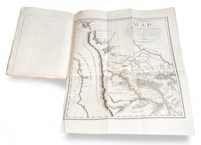
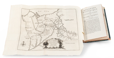
Rare early map of Ohio from an anonymous source, packed with contemporary and historical information.
We have dated the map at circa 1824, based upon the appearance of Holmes County (formed January 10, 1824) and the configuration of the southeast corner of Mercer County, which was modified to its modern configuration on March 1, 1826.
The map provides an unusual amount of detail, including the location of the "Northern Boundary as claimed by Ohio," the Connecticut Western Reserve, the Fire Lands, Steubenville District, Marietta District, New Purchase, Piqua Distric, Delaware District, Cincinnati District, Virginia Military District, Chillicothe District, US Military District, and other early divisions. The map also notes the old district lines, county lines, early roads, distances, County Seats, towns, and Canals.
The map is likely from an early Ohio Guide book, but we have not been able to identify the source.

![Carte Qui Contient La Maniere Dont Se Fait La Chasse Des Bouefs Sauvages . . . [Buffalo, Niagara Falls, Calumet Village, Huron & Illinois Indians]](https://storage.googleapis.com/raremaps/img/small/93146.jpg)