|
||

|

|
|

|
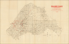
Rare early map of the El Cajon area, comprising the east end of the El Cajon Valley and the former Rancho El Cajon, showing the lands of the Pacific Coast Land Bureau which were then being prepared for sale, with an inset map of greater San Diego, showing the location of the "S" Tract in Ranch El Cajon.
This rare promotional map includes a map, the names of the various land agents and auctioneers handling the sale of the property and the financing terms available to buyers. The map shows the course of the San Diego Flume Company line as it winds its wsay thrugh the valley, along with the subdivided lots at the west end of the Valley and the must larger parcels to the east. Several landowers are noted, including Louis Guillaum, W.E. Flinn and Jonathan Perkins. Several early East County Roads are also shown, along iwth the Monte Tunnel.
The Pacific Coast Land Bureau had two noteworthy projects in San Diego County, this development in the El Cajon Valley and a development which would become known as "La Jolla Park." As noted in Richard F. Pourade's The History of San Diego,
By mid-1886 several thousand persons were arriving in San Diego monthly by train and ship. . . . A townsite was laid out in El Cajon Valley by the El Cajon Valley Company, of which Ephraim Morse was a principal figure. A second hotel, the Corona, had an observation tower from which prospective buyers could select their lands. The Pacific Coast Land Bureau loaded fifteen carriages and coaches with prospective buyers and took them to see the beauties of the valley. Lots were sold in a spirited auction. The El Cajon Valley Company also laid out the inland town of Lakeside and construction of a hotel there was begun.
While some of the land was undoubtedly sold, a significant portion of the S Tract was still unsold and the portion south of the Interest Highway 8 was purchased shortly after World War II by Col. Ed Fletcher and used as a family retreat.
The Pacific Coast Land Bureau was an active agent for the sale of real estate in Southern California. As noted by Enda Monch Parker at p. 110-111 of The Southern Pacific Railroad and Settlement in California (Pacific Historical Review, Vol. VI, no. 2, 1937)
the Pacific Coast Land Bureau was of definite assistance to the Southern Pacific. This Bureau, active in the [1870s and 1880s], was organized by a number of landowners in San Francisco. With offices at 22 Montgomery Street, it conducted sub-agencies in each [Southern California] county, and branch offices in Omaha, New York, New Orleans, London and Hamburg. in its publication, the California Guide Book, the Bureau stated taht it was the General Agent for hte sale of lands belonging to the Central and Southern Pacific Railroads.
The map is extremely rare. OCLC does not locate an example of the map and we have found no other references to the map in any public or private collections.
The Schmidt Lithography Company was based in San Francisco. Max Schmidt, a German immigrant, founded his first printing business in 1873, and he was one of the first printers to use lithography on the West Coast. His plant burned twice, in 1884 and 1886, but by the 1890s he ran a factory in San Francisco, as well as branches in Portland and Seattle.
During the 1906 earthquake and fire the company’s premises were destroyed again. Schmidt quickly acquired a nearby paper factory and production continued practically uninterrupted. Within two years of the fire, Schmidt had rebuilt on the site of his former factory at the corner of Second and Bryant Streets.
Schmidt’s company was best known for its printed labels, but they also produced other items like separately-issued prints. The company was once the largest printing company on the West Coast and today they are remembered for the clock tower that still stands at Second and Bryant Streets.
![Gray's New Map of California [Yosemite & San Francisco insets]](https://storage.googleapis.com/raremaps/img/small/89713.jpg)
![California Wine Land of America [Sauterne, Burgundy]](https://storage.googleapis.com/raremaps/img/small/93654.jpg)