This item has been sold, but you can enter your email address to be notified if another example becomes available.


|
||

|

|
|

|
Stock# 2412
Description
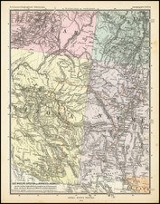
A virtual textbook of early 1860s transitional territorial borders. Colona, the pre-Colorado territorial name is shown. New Mexico is above Arizona (Baylor line). The the Territory of Shoshone is shown (pre-Idaho). Nevada's eastern border is nearly at the western edge of Salt Lake, an early effort to reduce the Mormon influence, although its eastern border is very odd. Nevada's lower tip, which would include Clark County (Las Vegas), is shown in Arizona. The map includes marvelous detail, including Indian names, forts, roads and explorers routes, mountains and rivers. It also elaborately tracks the ocean currents and sea routes. Excellent topographical detail. An essential map for western collectors.
![[ British Colonies in North America & Caribbean ] L'Amerique Angloise, ou Description des Isles et Terres du Roi d'Angleterre dans l'Amerique, Avec de nouvelles Carte de chaque Isle & Terres](https://storage.googleapis.com/raremaps/img/small/102812.jpg)
![A Map of Lewis and Clark's Track Across the Western Portion of North America, from the Mississippi to the Pacific Ocean. By Order of the Executive of the United States in 1804, 5 & 6. . . . [Complete with 3 volumes of Text: Travels to the Source of the Missouri River and Across the American Continent to the Pacific Ocean. Performed by Order of the Government of the United States, in the Years 1804, 1805, and 1806].](https://storage.googleapis.com/raremaps/img/small/81775.jpg)
![Amerique Septentrionale divisee en Ses Principales parties . . . . 169 [California as an Island]](https://storage.googleapis.com/raremaps/img/small/91231.jpg)