The item illustrated and described below is sold, but we
have another example in stock. To view the example which
is currently being offered for sale, click the
"View Details" button below.


|
||

|

|
|

|
Stock# 2411
Description
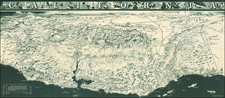
Outstanding Map of the Southwestern US immediately prior to the Gadsden Purchase. Includes a number of early territorial borders, including a misshaped Indian Territory, massive Nebraska Territory and New Mexico Territory extending into modern day Colorado and Kansas. Includes early notes on the Great Basin. A number of early roads are shown in Texas and throughout the Plains. Includes information on early forts, Indians, roads, rivers, etc. An excellent and detailed map of the Southwest during one of the most fascinating periods of western history. From the scarce George Cox edition, dated Jan. 1st 1853. Not in Wheat.
![[California, Texas, and Southwest Globe Gore] with [Strait of Anian Globe Gore]](https://storage.googleapis.com/raremaps/img/small/99425.jpg)

![(California Gold Rush Artist) [Autograph Letter, from American artist William McIlvaine Jr. to artist William Thompson Russell Smith, mentioning Fronconia Notch. White Mountains]](https://storage.googleapis.com/raremaps/img/small/97179.jpg)