


|
||

|

|
|

|
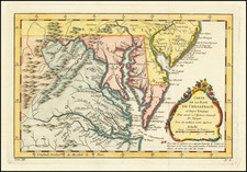
Rare separately issued map of the Ablbemarle and Chesapeake Canal.
Th map illustrates the region between Cape Charles and Cape Lookout, depicting the two parts of the Albemarle and Chespeake Canal, including the Elizabeth River to North Landing River Section (8.5 Miles) and the Coinjock Bay to North River Section (5.5 Miles), along with detailed information in the interior, including rivers, towns, roads, railroads, etc.
The Albemarle and Chesapeake Canal was built in 1856-1860 to afford inland navigation between Chesapeake Bay and Albemarle Sound. It consists of two canals, thirty miles apart; one eight and one-half miles long, connecting Elizabeth River with North Landing River in Virginia, the other five and one-half miles long, connecting Currituck Sound with North River in North Carolina. First authorized in 1772, the early history of the Albemarle and Chesapeake Canal can be characterized as all acts and no action. No less than ten acts were passed in both Virginia and North Carolina over a period of 83 years before construction finally began in 1855.
The man who was finally able to begin the canal was Tidewater Virginian Marshall Parks, Jr. Parks' father had been superintendent and chief engineer of the Dismal Swamp Canal during its first major period of reconstruction in the late 1820s. The younger Parks had also been an official with the Dismal Swamp Canal Company and was familiar with the canal's problems. He visualized the Albemarle and Chesapeake Canal as the answer to more efficient commercial trade between the two regions.
The new canal would be wider and deeper than most others of its day. Parks planned for the Canal to handle the larger steamers and future growth. It would also have only one lock, instead of the Dismal's then seven, considerably reducing passage time. Construction of the Albemarle and Chesapeake was accomplished by seven steam dredges on floating platforms. When the canal was finished, it was an engineering marvel. It consisted of only one lock and two relatively short man-made channels, the Virginia Cut and the North Carolina Cut. The single lock, which balanced the lunar tides of the southern branch of the Elizabeth River with the wind driven ones of the North Landing River and Currituck Sound, was 40 feet wide and 220 feet long, the largest along the Atlantic coast and the second largest in the entire U.S.
There are several editions of the map, including a Hosford & Co. editions of 1856 (OCLC locates 2 examples) 1857 (1 example), 1858 (2 examples) and 1859 (Old Print Gallery, 1986)) and this very rare re-issue of 1866, for which no copies are located in OCLC, although we also had an 1866 edition in 2006.
![[Revolutionary War Plans of New York, Boston, Charleston, Delaware River to Philadelphia & Havana] Various Plans and Draughts of Cities, Towns, Harbours &c . . .](https://storage.googleapis.com/raremaps/img/small/83450.jpg)
![A Topographical Description of Such Parts of North America as are Contained in the (Annexed) Map of Middle British Colonies, &c. in North America [with map:] A Map of the Middle British Colonies in North America. First published by Mr. Lewis Evans ... in 1755; and since Corrected and Improved, as also extended with the addition of New England, and bordering parts of Canada; from actual surveys ... by T. Pownall](https://storage.googleapis.com/raremaps/img/small/100077.jpg)
![[ Southern Railroads ] Railroad Map of the Southern States Shewing the Southern & Southwestern Railway Connections With Philadelphia. 1862 . . . Prepared by Thomas Kimber Jr., Chairman of the Committee on Inland Transportation of the Board of Trade of Philadelphia](https://storage.googleapis.com/raremaps/img/small/103211.jpg)
