


|
||

|

|
|

|
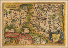
Rare Dutch edition of Sir Thomas Modiford's map of Jamaica, which appeared in the 1688 Amsterdam edition of Blome's A Description of the Island of Jamaica ... Territories in America ....
Shows Jamaica divided into its parishes. Ports and bays are identified. Mountains are shown by shading. Jamaica had been captured by the British from the Spanish in 1655. Kingston, the present-day capital, had not yet been built (established 1692) when this map was drawn. There is a large untitled inset of North America extending from the Chesapeake Bay to Venezuela, enclosing the Caribbean Sea and the West Indies.
The large inset of Florida, the Southeast and Gulf Coast, is a Dutch copy of one of the earliest English maps of the region, first published in 1671.
The map is a more decorative version of the map which appeared in Henri Justel's Recueil de Divers Voyages faits en Afrique et en l'Amerique, qui n'ont point este encore publiez Contenant l'Origine, les Moeurs, les Coutumes & le Commerce des habitans de ces deux Parties du Monde. … (Paris, Louis Billaine, 1674).
The Modiford map, originally entitled New and Exact Map of Ye Isle of Jamaica, as it was lately Surveyed by orer of Sr. Thoma Modiford, Bart. . . .was originally printed for Richard Blome in 1671 amd is based upon the surveys ordered by Modiford, the 4th Governor of Jamaica..

![(Southeast United States) Carte de la partie sud, des Etats Unis de L' amerique septentrionale [Map of the southern part of the United States of North America]](https://storage.googleapis.com/raremaps/img/small/98738.jpg)
![The West India Islands, and Central America [with] Jamaica](https://storage.googleapis.com/raremaps/img/small/78675.jpg)