


|
||

|

|
|

|
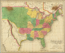
Separately issued War of 1812 map of the United States. Shelton & Kensett were among America's foremost engravers of the early 19th Century and their work is highly prized among collectors.
One of the very few separately issued printed maps of the War of 1812. The present example is an edition of the map with 9 vignettes illustrating the naval battles of the War of 1812, 2 more than the first edition of the map. The map includes a number of features which rarely appear on printed maps, most notably the naming of Orleans Territory as a subdivision of Lousisana. This is the only printed map we have ever seen which refers to and delineates an American Territory by this name. The map also includes a number of other fascinating early annotations and a fine representation of the post roads and other routes throughout the US. Interesting annotation regarding the fishing and grapes in Northern Illinois. Curious delineation of the Northwestern States and Territories, with Illinois pushed off Lake Michigan. Excellent early Indian details and a a fine treatment of Spanish Florida.
Orleans Territory was created on October 1, 1804 by the Organic Act of March 26, 1804 and became the first subdivision of Louisiana Territory following the Louisiana Purchase. The Territory consisted of all of the Louisiana Purchase south of the 33rd parallel, with the region to the North called the District of Louisiana. The District of Louisiana was later renamed Louisiana Territory. The Orleans Territory ultimately became the State of Louisiana on March 12, 1812, at which time Louisiana Territory was renamed the Missouri Territory.) On April 10, 1805, the Territorial Legislature organized 12 counties (Orleans County, LaFourche County, German Coast, Acadia County, Iberville County, Attakapas County, Pointe Coupée County, Opelousas County, Rapides County, Concordia County, Natchitoches County and Ouachita County). The Florida Parishes on the east bank of the Mississippi were not included in Orleans Territory at this time, as they still part of the Spanish territory of West Florida until the region was annexed in 1810. The western boundary with Spanish Texas was not fully defined until the Adams-Onís Treaty in 1819. A strip of land known as the Sabine Free State just east of the Sabine River served as a neutral ground buffer area from about 1807 until 1819.
There appear to be at least three version of the map, plus a re-issue in 1825 by Lewis Robinson. The other early editions include an edition with 7 vignettes and an edition with 10 vignettes. The 9 vignette edition (copyrighted on November 8th, 1813) is actually from a completely different plate, making it difficult to determine the trhue sequence of the editions.
The 10 vignette edition can be seen here: /gallery/detail/30877
The 7 vignette edition can be seen here: www.davidrumsey.com/luna/servlet/detail/RUMSEY~8~1~222569~5505625:An-Improved-Map-of-the-United-State
![The Pathfinder Railway Guide Map. Western Section [Alaska, Yellowstone Park / Philippines / Hawaii / Guam]](https://storage.googleapis.com/raremaps/img/small/97894.jpg)
![Colton's United States of America [State of Colona named]](https://storage.googleapis.com/raremaps/img/small/90086.jpg)