This item has been sold, but you can enter your email address to be notified if another example becomes available.


|
||

|

|
|

|
Stock# 23711
Description
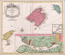
Striking chart of Malta and Goza, with a large inset of Valetta and its harbor and fortifications.
The work is exceptionally detailed and includes topographical details, soundings, anchorages, and a host of other details. The Aqueduct on Malta is shown, along with several other fortified towns. Includes and elaborate cartouche, compass roses, sea monsters, etc.
One of 16 charts in Henri Michelot and Laurent Bremond's] Carte Generalle dele Mer Mediterranee, which was originally published along with their work depicting the ports of the Mediterranean in 1718, with an English translation in 1725.

![[Hand-Drawn Map Showing the Extent of the Ottoman Empire]](https://storage.googleapis.com/raremaps/img/small/99654.jpg)

![[Majorca, Minorca, Ibiza] Carta Esferica de Las Yslas Baleares y Pithyusas, arreglada a la que se construyo en 1807 en la Direccion Hydrographica de Madrid. Publicala Dn. Jose de Espinosa Gefe de Esquadra de la Rl. Armada y primer Director de dicho Establecimiento Londres Año 1812.](https://storage.googleapis.com/raremaps/img/small/58779.jpg)