|
||

|

|
|

|
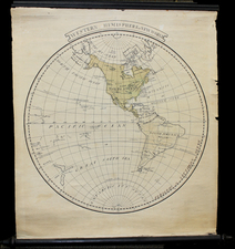
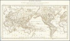
Spectacular double hemisphere map of the world, surrounded by allegorical decorations and models of the heavens, by Louis Charles Desnos.
Desnos's World Map was originally issued by Nicolas De Fer in 1694 and was later extensively revised by Danet in the mid-18th Century, before being revised again by Desnos. Desnos issued several editions of the map, with this being an early edition by Desnos.
The most significant cartographic update is in the Northwestern part of America, where the Sea of the West is prominently shown (twice!) and a highly embellished depiction of the discoveries during Tchirikow's voyage in 1741 is given. The prospect of both Northwest and Northeast Pasages clearly depicted on the map, including a marvelous channel extending northeast from the Sea of the West (Mer de l'Oest).
The map also tracks the circumnavigations of a number of earlier explorers, including Magellan, LemaIre, Schouten, and others. The depiction of Australia and New Zealand appears in the style popularized by the Dutch, which endured until Cook's Voyages, which comenced shorty after the publication of this map.
While the De Fer editions of the map appear occasionally on the market, we note only 2 other examples of the Desnos appearing at auction or in dealer catalogues in the past 30 years (including a heavily damaged and restored example which appeared at auction in 2004) and an example offered by Roderick Barron in 1996).
![[Eastern Hemisphere] Le Globe Terrestre Represente En Deux Plans-Hemispheres . . . 1740](https://storage.googleapis.com/raremaps/img/small/92751.jpg)