|
||

|

|
|

|
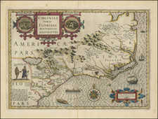
Second state of Henry Mouzon's landmark 4-sheet map of the Carolinas, the primary source for the geographical details of the Carolinas for the American, English and French armies during the American Revolution.
Mouzon's map was unquestionably the most important general map of the period. The map was utilized by three of the most important commanders of the American Revolution. George Washington's copy, folded and mounted on cloth, resides in the collections of The American Geographical Society. The French commander, the Comte de Rochambeau's copy belongs to the collections of the Library of Congress. British commander, Sir Henry Clinton's copy is held in the William L. Clements Library at the University of Michigan.
Published just five weeks after the Battle of Lexington and Concord, Mouzon's map is the best for the Carolinas at the beginning of the American Revolution. It was used by both armies as a reference for strategic planning. George Washington apparently owned two copies, now at Yale and the American Geographical Society respectively; General Rochambeau's is at the Library of Congress; and Sir Henry Clinton's at the Clements Library (Schecter and Lester).
The map was normally published folded into Thomas Jefferys' American Atlas, London, 1775. As it was slightly oversized, almost all copies suffered some damage to the left-hand margin.
Mouzon's large-scale map is the most comprehensive and detailed that had yet appeared for these two colonies. It was the first to extend far enough to the west to include all three of their topographical regions: the Tidewater, the Piedmont, and the Back Country. It includes all of their "mountains, rivers, swamps, marshes, bays, creeks, harbors, sand banks, and soundings on the coast; with the roads, and Indian paths; as well as the boundary or provincial lines, [and] the several townships and other divisions of the land in both the provinces."
For several decades, Mouzon's map was a primary source for information about the geography and topography of the Carolinas, copied frequently by other mapmakers for its remarkable detail and accuracy. Mouzon based his map on years of personal surveying experience and over a decade spent critically assessing and incorporating previous information. As noted by Pritchard and Taliaferro, Mouzon's "appeared on the eve of the American Revolution, and its up-to-date geography made it the most widely consulted map of the area used in the war effort."
This is truly a landmark map. Its excellence and significant improvement of the depiction of the vast Carolinas was recognized by all countries involved in the Revolutionary War, and it remained unrivaled well into the 19th century. The present example includes some annotations to the counties, including the manuscript addition of Wayne County, North Carolina, which was established on November 2, 1779 (named for "Mad Anthony" Wayne) and the renaming of several islands in the near Albermarle Sound, strongly suggesting that the map was in use during the American Revolution.
Relatively little is known about Mouzon. At the time he was preparing the map, Mouzon, a professional surveyor, resided in Craven County, and died in April 1777, shortly after publication of his map. As noted in the Craven County Digital History Exhibit:
Mapmaker and civil engineer, Henry Mouzon, Jr. (1741-1807) was the grandson of a Huguenot immigrant to South Carolina who held land grants in Berkeley County. Henry, Jr. was born in Craven (now Williamsburg) County, South Carolina. After his father's death in 1749, eight-year-old Henry Jr. was sent to France for his education, where it is presumed that he learned mapmaking skills. He received his first important public commission in 1771, when he and Ephraim Mitchell (subsequently the surveyor general of South Carolina) were appointed by Governor Lord Charles Greville Montague to survey the boundaries of the civil districts of South Carolina.
The first notice of Mouzon's work was announced in an advertisement in THE SOUTH CAROLINA AND AMERICAN GENERAL ADVERTISER in May 1774, which announced his intention to publish a map of South Carolina only in January 1775. After expanding the scope to both North and South Carolina, Mouzon's map was first published by Sayer & Bennett in 1775.
Mouzon's map is derived from a number of sources. His depiction of South Carolina is based upon James Cook's, A MAP OF SOUTH CAROLINA (1771) and A MAP OF THE PROVINCE OF SOUTH CAROLINA (1773) and William De Brahm's MAP OF SOUTH CAROLINA AND A PART OF GEORGIA (1757). Mouzon added greater definition of the rivers and more detail regarding the native settlements located to the west of the Cherokee Line. For his treatment of North Carolina, Mouzon used John Abraham Collets' A COMPLEAT MAP OF NORTH- CAROLINA (1770), adding counties and better detail for the Catawba River and its tributaries. Mouzon also had access to other manuscript sources for his treatment of the North Carolina Coastline, as the hydrographic information varies significantly from Collet's map.
The present example is the second state of the map, with Fort Sullivan.

![[French Colonization in Florida and the Southeast] La Floride Francoise Dressee sur La Relation des Voiages que Ribaut, Laudonier, et Gourgues y ont faits in 1562, 1564 et 1567 . . .](https://storage.googleapis.com/raremaps/img/small/91072.jpg)