
This item has been sold, but you can enter your email address to be notified if another example becomes available.


|
||

|

|
|

|
Stock# 23647
Description
Detailed map of Algeria, with large insets of the Algiers environs, and two smaller plans of the Gulf of Oran and the area around Constantine, from this scarce mid 19th Century British Atlas.
Fullarton's Royal Illustrated Atlas, the last highly decorative atlas published in England. Even the maps without views or figures are beautifully engraved and colored with a mixture of printed color and hand color. Swanston, Petermann, Bartholomew, Macnab and Johnson engraved the maps. The maps bear a superficial resemblance to Keith Johnston's Royal Atlas. Fullarton frequently gives the sources for his maps - for the United States maps he gives Calvin Smith and Tanner as sources.
![Egypt called in the Country Missir by Monsr. D'Anville of the Royal Academy of Belles Lettres, & of that of Siciences [sic] of Petersburg Secretary to H.S.H. the Duke of Orleans. MDCCLXV.](https://storage.googleapis.com/raremaps/img/small/49130.jpg)
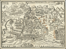
![[The Siege of Peñón de Vélez de la Gomera in 1564] El Pignon / Il vero & natural sito della Villa di Velez de Gomera, & l'inespugnabile forte et castello chiamato il Pignon, situato in Africa di Barbaria, a l'incontro d'Ispagna, newl qual luogo Solemano li Mori, et Corsari di mare . . .](https://storage.googleapis.com/raremaps/img/small/75226.jpg)
![Fezzae et Marocchi Regna Africae Celeberrima, describebat Abrah: Ortelius. [Fez and Morocco, the most famous Kingdoms of Africa, as described by Abraham Ortelius]](https://storage.googleapis.com/raremaps/img/small/94255.jpg)
