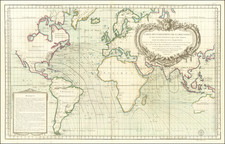


|
||

|

|
|

|
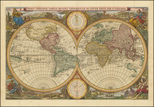
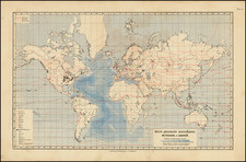
Gorgeous double hemisphere map of the world, which includes many of the great 17th Century cartographic myths and errors.
A massive land extension north of California reaches nealy to Asia and shows the Straits of Anian and NW Passage, with dozens of early place names on the NW Coast, including Quivira Regnum, which appears twice (one just opposite the Straits of Anian and once just east of the Rio Grande River.
North America is misconfigured in a manner similar to early world maps by Hondius. A partial New Zealand and Australia both appear. The tracks of Magellan's circumnavigation are shown, along with other cartographic misconceptions.
Four allegorical female figures represent the four continents (Europe, Asia, America and Africa), along with exotic allegorical scenes.

![(Apian World Map) La Cosmographia de Pedro Apiano, corregida y añadida por Gemma Frisio ... El Sitio y Descripcion de las Indias y Mundo Nuevo, sacada de la Historia de Francisco Lopez de Gomara, y de la Cosmographia de Ieronymo Giraua Tarragonez [with map:] Mappa Mundi](https://storage.googleapis.com/raremaps/img/small/100234.jpg)