


|
||

|

|
|

|
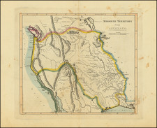
Carey's map of Missouri Territory, shortly after the return of Lewis & Clark in the same year as the issuance of their highly influential map of the region from the Missouri River to the Pacific Ocean (also issued by Matthew Carey) is the first great map of the American West to appear in a Commercial Atlas published in the United States.
Carey's map is a curious amalgam of information. While it includes highly up to date Lewis & Clark Geography in certain portions of the map, other portions continue to rely upon Soulard and earlier material furnished by Lewis. Stretching from the Mississippi and Missory Rivers and the Atlantic Ocean, Carey's Missouri Territory . . . and John Melish's map of the United States represent landmarks in American Cartographic history, each looking for the first time to explain the vast tracks of land obtained by Jefferson in the Louisiana Purchase and begin to reconcile the information then being provided by Arrowsmith, Lewis & Clark, Humboldt and other sources. An essential map of American Collectors.
![[ The Ptolemaic Universe ] Situs Terrae Circulis Coelestibus Circundatae . . .](https://storage.googleapis.com/raremaps/img/small/101512.jpg)
![[ Exceptional original hand-color with highlights in gold ] Typus Aspectuum Oppositionum Et Coniunctionum Etz In Planetis](https://storage.googleapis.com/raremaps/img/small/81866.jpg)