


|
||

|

|
|

|
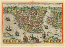
Rare map / birdseye view of Istanbul, from Jansson's monumental town book.
Jansson's view is one of the finest and most sought-after views of Istanbul. Viewed from the village of Scutari, the City is shown with all its fortifications, the original Genouse district of Galata on the opposite bank of the Golden Horn to the right.
European galleons and Turkish galleys fill the seas of the Bosporus and Golden Horn. The great buildings of the 16th Century Istanbul during the reign of Suleiman the Magnificent can be clearly seen, including the "Suleymaniye Mosque" and the "Topkapi" palace. The lower center is filled with a parading Turkish horseman and troop of Janissaries.
The view is the third state of the engraving, with the roundels present in the earlir Braun & Hogenberg editions removed. Jansson's view is much rarer than the first two states by Braun and Hogenberg.
Jansson's 8 volume Theatrum Urbium was the most comprehensive Dutch townbook of the 17th Century. While similar in format to Braun & Hogenberg's Civitatis Orbis Terrarum, Jansson's was in many respects a significant improvement, both in the scope of the towns depicted and the quality of the views. Moreover, it was perhaps the only work by Jansson which surpassed the comparable work of the Blaeu Family, whose own atlas of town views was never completed.
In 1653 Jansson acquired the nearly 500 plates of the Civitates Orbis Terrarum from Abraham Hogenberg, of which 232 were adapted and incorporated into the town books. For many plates of the cities of the Netherlands, Jansson ordered new copperplates, many of which were engraved after works by his rival, Blaeu.
Jan Janssonius (also known as Johann or Jan Jansson or Janszoon) (1588-1664) was a renowned geographer and publisher of the seventeenth century, when the Dutch dominated map publishing in Europe. Born in Arnhem, Jan was first exposed to the trade via his father, who was also a bookseller and publisher. In 1612, Jan married the daughter of Jodocus Hondius, who was also a prominent mapmaker and seller. Jonssonius’ first maps date from 1616.
In the 1630s, Janssonius worked with his brother-in-law, Henricus Hondius. Their most successful venture was to reissue the Mercator-Hondius atlas. Jodocus Hondius had acquired the plates to the Mercator atlas, first published in 1595, and added 36 additional maps. After Hondius died in 1612, Henricus took over publication; Janssonius joined the venture in 1633. Eventually, the atlas was renamed the Atlas Novus and then the Atlas Major, by which time it had expanded to eleven volumes. Janssonius is also well known for his volume of English county maps, published in 1646.
Janssonius died in Amsterdam in 1664. His son-in-law, Johannes van Waesbergen, took over his business. Eventually, many of Janssonius’ plates were sold to Gerard Valck and Pieter Schenk, who added their names and continued to reissue the maps.

![[ Cyprus, Syria, Palestine, etc. ]](https://storage.googleapis.com/raremaps/img/small/103027.jpg)
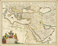
![(Ancient Turkey and Middle East) Tabula Itineris Decies Mille Graecorum Cyro merentium contra fratrem Artaxerxem Regem Persarum [The Retreat of the Ten Thousand Greeks]](https://storage.googleapis.com/raremaps/img/small/89459.jpg)
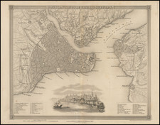
![[Iskenderun] The Gulf of Alexandretta or Scandaroon](https://storage.googleapis.com/raremaps/img/small/73675.jpg)