


|
||

|

|
|

|
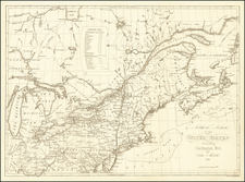
Rare miniature map New England, from the rare first edition of Gibson's Atlas Minimus, including 2 pages of accompanying text.
The map extends from the St. Lawrence and Province of Sagadahock to Long Isand and the Hudson River, centered on the Province of Main. This earlier edition can be distinguished from the second edition by the lack of a reference to Vermont. Nice detail in Massachusetts Bay Colony and New Hampshire. Annotation describes the conditions of the region. Connecticut and Rhode Island are also noted.
John Gibson flourished in London from 1748 to 1773. He was most likely born ca. 1724. As a young man he was apprenticed to John Blunbell of the Stationers Company, and then to John Pine. He was made free of the Company in 1748. Gibson proved a talented geographer and engraver who produced numerous maps, especially for books and magazines. He worked in collaboration with other map sellers such as Emanuel Bowen and John Roque. His best-known work was the pocket atlas, The Atlas Minimus (1758). Although little is known about his life beyond his publications, he was imprisoned for debt in King’s Bench from May to June of 1765.

![(Ecclesiastical Districts of the American Northeast) Tav. CXXVIII Provincia ecclesiastica di Nuova York [e di Boston]](https://storage.googleapis.com/raremaps/img/small/89777.jpg)