


|
||

|

|
|

|
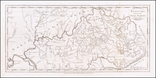
Excellent later 18th Century regional map showing all of Florida and the Gulf Coast to the Sabine River and the extending north along the Mississippi to just North of St. Louis and including th course of the Ohio. An sent shows the region around Kansas City. Many forts, Indian place names and other details in the US western frontier. Certainly one of the earliest maps to include detail around Kansas City. From one of the most famous and important works on the East and West Indies of the 18th Century. A nice dark impression.
Rigobert Bonne (1727-1794) was an influential French cartographer of the late-eighteenth century. Born in the Lorraine region of France, Bonne came to Paris to study and practice cartography. He was a skilled cartographer and hydrographer and succeeded Jacques Nicolas Bellin as Royal Hydrographer at the Depot de la Marine in 1773. He published many charts for the Depot, including some of those for the Atlas Maritime of 1762. In addition to his work at the Depot, he is best known for his work on the maps of the Atlas Encyclopedique (1788) which he did with Nicholas Desmarest. He also made the maps for the Abbe Raynals’ famous Atlas de Toutes Les Parties Connues du Globe Terrestre (1780).
More than his individual works, Bonne is also important for the history of cartography because of the larger trends exemplified by his work. In Bonne’s maps, it is possible to see the decisive shift from the elaborate decorations of the seventeenth century and the less ornate, yet still prominent embellishments of the early to mid-eighteenth century. By contrast, Bonne’s work was simple, unadorned, and practical. This aesthetic shift, and the detail and precision of his geography, make Bonne an important figure in mapping history.
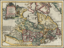

![Partie De L'Amerique Septent? Qui comprend La Nouvelle France ou Le Canada . . . [Large Great Lakes Inset]](https://storage.googleapis.com/raremaps/img/small/48752.jpg)