|
||

|

|
|

|
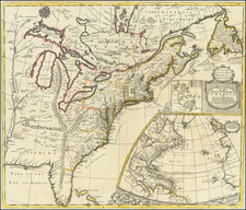
Fine full original color example of Carrington Bowles exceedingly rare map of The British Dominions in North America, published in London in 1763.
The first edition of Carrington Bowles spectacular map of North America, showing the British Colonies in North America extending to the Mississippi River, marvelous detail in the western part of the Mississippi Valley, including parts of Louisiana Territory, and a spectacular cartouche, with an early printing of the Treaty of Peace of 1763 below the cartouche.
The map was followed by editions of 1783, 1796 and 1808, each of which is virtually unobtainable. In addition, a variant edition was issued in 1783 with a completely revised cartouche, under the title " New and Accurate Map of North America and the West Indies, Exhibiting the extent and boundaries of the United States, the British Dominions . . .", with a completely different cartouche, which includes an illustration of an American flag.
The map also comes with exceptional provenance, having been owned by James H.R. Cromwell, former ambassador to Canada and the first husband of Doris Duke. Duke married twice, the first time in 1935 to James H. R. Cromwell, the son of Palm Beach, Florida society doyenne Eva Stotesbury. Cromwell, a New Deal advocate, used his wife's fortune to enter the political arena, becoming U.S. Ambassador to Canada in 1940. The couple had a daughter, Arden, who lived for only a day. They divorced in 1943.

![[Signed Political Satire Artwork] Vietnam ... Vietnam ... Vietnam ...](https://storage.googleapis.com/raremaps/img/small/68726.jpg)