


|
||

|

|
|

|
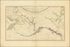
Highly detailed chart of the North Pacific, based upon Cook's map of 1784 & updated in 1794 to include information from Vancouver & MacKenzie.
This edition adds information from 18th Century Russian sources. One interesting feature is the supposed course of the Columbia extending due north into British Columbia. The map includes a nearly daily course of Cook's voyage, details in Northern Canada and along the NW Coast of America, including the region explored by Vancouver, details on the NW Passage from Hans Sloan's Japanese map of the world, information on certain arctic coastlines from Russian sources and many other annotations.
The basis for the map was Henry Roberts' chart of 1784, produced under the supervision of James Cook. Roberts was an officer on Cook's third voyage, and his charts provided the first accurate mapping of the northwest coast of North America, dispelling many of the fantastic theories that had plagued the region for years.
In 1794, William Faden commissioned the engraver Louis Stanislas D'Arcy de la Rochette to update Roberts' chart with new data gathered over the last decade. A note on the map states:
The Interesting Discoveries made by the British and American Ships, since the first Publication of this Chart in 1784, Together with the Hydrographical Materials, lately procured from St. Petersburg and other places, have enabled Mr. De la Rochette to lay down the Numerous Improvements which appear in the Present Edition.
In describing the first edition, Cohen & Taliaferro (Catalogue 62) note:
This legendary lost chart was drawn by Henry Roberts for the authorized atlas of Cook's third voyage, but because of disputes among the editors, it was never included. It is now known that the plate for Roberts' chart, " version more elaborate than that [included] in the authorized atlas" (Campbell), was purchased by Faden and published separately. Th[e] exceptionally rare first state of the Roberts-Faden chart is the first published map to show the discoveries of Samuel Hearne in the Canadian Arctic. . . .
Although a few examples of the chart were known, including one belonging to the great Americana collector, Thomas Streeter, its true importance was not recognized until 1985, when a proof copy was acquired by the British Library . . .
...the [map] includes a number of Alaskan place-names not found on the authorized version [in the account of Cook's third voyage]. . .
This Roberts chart also contains informaiton on interior geography not included on the [official map]. The source for this information came from Samuel Hearne's c.1772 manuscript map of the Coppermine River, in the possession of the Hudson's Bay Company, and which had never before appeared in print. The Company suppressed Hearne's map to protect its interests in the north. This was important information because Hearne's map showed the impossibility of a Northwest Passage through Hudson's Bay, and it is curious that the Company had not released it to settle arguments over a point that continued to occupy public attention. . .
William Faden (1749-1836) was the most prominent London mapmaker and publisher of the late-eighteenth and early-nineteenth centuries. His father, William Mackfaden, was a printer who dropped the first part of his last name due to the Jacobite rising of 1745.
Apprenticed to an engraver in the Clothworkers' Company, he was made free of the Company in August of 1771. He entered into a partnership with the family of Thomas Jeffreys, a prolific and well-respected mapmaker who had recently died in 1771. This partnership lasted until 1776.
Also in 1776, Faden joined the Society of Civil Engineers, which later changed its name to the Smeatonian Society of Civil Engineers. The Smeatonians operated as an elite, yet practical, dining club and his membership led Faden to several engineering publications, including canal plans and plans of other new engineering projects.
Faden's star rose during the American Revolution, when he produced popular maps and atlases focused on the American colonies and the battles that raged within them. In 1783, just as the war ended, Faden inherited his father's estate, allowing him to fully control his business and expand it; in the same year he gained the title "Geographer in Ordinary to his Majesty."
Faden also commanded a large stock of British county maps, which made him attractive as a partner to the Ordnance Survey; he published the first Ordnance map in 1801, a map of Kent. The Admiralty also admired his work and acquired some of his plates which were re-issued as official naval charts.
Faden was renowned for his ingenuity as well as his business acumen. In 1796 he was awarded a gold medal by the Society of Arts. With his brother-in-law, the astronomer and painter John Russell, he created the first extant lunar globe.
After retiring in 1823 the lucrative business passed to James Wyld, a former apprentice. He died in Shepperton in 1826, leaving a large estate.

![[ Chinese Voyages To America, etc. ] Memoires De Litterature, Tires Des Registres De L'Academie Royale Des Inscriptions et Belles-Lettres Depuis l' annee M. DCC. XVIII. julques & compris l'annee M. DCC. XXV Tome Quarante-Neuvieme](https://storage.googleapis.com/raremaps/img/small/101296.jpg)