|
||

|

|
|

|
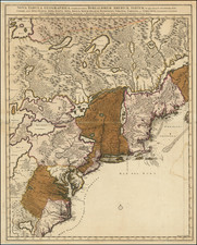
Important early Dutch sea chart from Sandy Hook and the Chesapeake in the North to Florida, the Gulf Coast, Yucatan, Caribbean and the Venezuelan Coastline, which appeared in Doncker's Zee-atlas ofte water-waereld, first published in Amsterdam in 1659.
Doncker's chart is one of the earliest Dutch sea charts to cover the region which includes the Southeastern US, Florida and Gulf Coast. Burden notes:
This chart appeared inteh first edition of Hendrick Doncker's Zee-Atlas, of which no surviving example is known. . . . Derived from the Hessel Gerritz [chart of] 1631, it illustrates Donckert's independent thought towards its content. Two distinct features the pronounced easterly sweep of the south-east coast, and an unusually promnent R. d. S.Petro feeding an enlarged Apalachee Bay.
Doncker's chart includes rhumb lines, compass rose, location of esturaries, settlements, and sea banks or shoals. Also includes soundings and scales. Decorative cartouche includes a native American, with sailing ships off the coast. This is the first edition of the map, which can be identified by the inclusion of Indian in the cartouche. A second edition was published in Doncker's Atlas in 1672. A third edition was published in 1676, with the plate enlarged.
Hendrik Doncker was a famous bookseller in Amsterdam, who started with the age of 22 years and ran his shop successfully for fifty years. He published his first sea atlas around 1659. Due to the fact, that Hendrik Doncker corrected and improved his charts more frequent then other well known map makers, as van Loon, Goos or Theunis, his business was quite successful and there was a high demand for his works and this reflected also the various improved and corrected editions of sea atlases he published. This map was published in a composit sea atlas by Pieter Goos, who was 'one of the best known maritime booksellers of Amsterdam' (Koeman), he published a number of different sea-atlases or pilot books, his work was very much derivative. With his 'Zee-Atlas' he relied heavily on Hendrick Doncker's 'Zee-Atlas' of 1659.
Doncker's chart is very rare on the market, with only 2 prior examples of the map listed in AMPR (Arkway 2001, Catalog 55:84--$9,500 and Swann Galleries, Sale 1974-June 19, 2003:81--$5,750 + premium (auction result).
Hendrik Doncker was a prominent bookseller in Amsterdam best known for his sea charts and nautical atlases. He issued his own original charts, which he updated frequently, and also worked with colleagues like Pieter Goos, for example to produce the pilot guide, De Zeespeigel. He died in 1699, after fifty years in business. His plates then passed to Johannes van Keulen.

![[ Yucatan ] Pas-kaart Van de Golff de Guanaios Met 't Canaal Tusschen Yucatan en I. Cuba . . .](https://storage.googleapis.com/raremaps/img/small/99320.jpg)
![[The Russian Question] Die Russische Frage. Ein Schauspiel von K. Simonow](https://storage.googleapis.com/raremaps/img/small/83978.jpg)