![[Florida Panhandle to Yucatan] Pas-Kaart Van de Golff van Mexico . . . By Gerard Van Keulen](https://storage.googleapis.com/raremaps/img/small/93130.jpg)


|
||

|

|
|

|
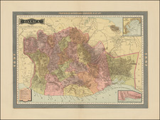
The Earliest Obtainable Sea Chart of the US Gulf Coast
Unrecorded variant edition of Van Keulen's chart of the Gulf Coast, from the Yucatan to Florida and centered on Texas, the earliest obtainable sea chart to focus this closely on Texas and the Gulf Coast.
"The main feature of this map is its originality of form. It is the first sea chart of the western portion of the Gulf of Mexico detailing the coastal waters of present-day Florida, Alabama, Mississippi, Louisiana and Texas. The geography is largely derived from the exceedingly rare Hessel Gerritsz chart. . ." (Burden #592). Cabo Escondido is likely Cape San Blas, near the mouth of the Apalachiola River. Bajo de Spirito Santo is the mouth of the Mississippi River.
The Van Keulen family followed the Blaeu family as the official sea chart makers of the Dutch East Indies Company. Their charts are of paramount importance in the development of Marine Cartography. The fourth book of the Zee-fakkel, dedicated to the Americas, is one of most important of all American cartographic works, substantially updating and improving all then existing compilations on the coast of the Americas.
There are 4 known states of the map, as described by Burden:
- State 1: 1684 - No page numbers in the corners
- State 2: 1687 - Page #14 at lower left
- State 3: 1695 - Costa de Piscadoras added for a second time (offshore at the top of the map). Large shoal added off the Yucatan Coast. Shoal off Florida extended into Baja de Spirito Sancto. Page number in 2 corners.
- State 4: 1734 - Coastal mountains in Mexico. Vooght's imprint removed. Gerard Van Keulen name replaces Johannis.
The present edition includes the shoal off the Yucatan coast, but has only 1 page number.
The Van Keulens were a family of chartmakers and publishers. The firm, In de Gekroonde Lootsman (In the Crowned Pilot), was founded in 1678 by Johannes van Keulen (1654-1715). Van Keulen originally registered his business as a vendor of books and instruments (specifically cross-staffs). In 1680, however, he gained a privilege from the States of Holland and West Friesland for the publication of pilot guides and sea atlases.
In that year, van Keulen released his Zee-Atlas (Sea Atlas), which secured him a name in the competitive maritime publishing market. In 1681, he published the first volume of Nieuwe Lichtende Zee-Fakkel (New Shining Sea Torch). This would be the first of an eventual five volumes originally published between 1680 and 1684. A sixth volume was added in 1753. The Zee-Fakel won van Keulen lasting fame. The atlas had charts compiled by Claes Jansz Vooght and artwork from Jan Luyken. It proved immensely popular and was reprinted until 1783. There were translations in French, English, Spanish, and Italian.
The late-seventeenth century was an auspicious time to enter the maritime chart business. Previous industry leaders had either closed shop, died, or retired, leaving space for a new competitor. Van Keulen proceeded to buy up the stock and privileges of several maritime publishing firms; the most notable was the stock of Hendrik Doncker, acquired in 1693.
Johannes’ son, Gerard (1678-1726) took over the business upon his father’s death. Gerard was a skilled engraver and mathematician. His talents were noticed, as in 1706 he was named as Hydrographer to the Dutch East India Company (VOC).
In turn, Gerard’s son Johannes II (1704-1770) came to run the shop. He was also tied to the VOC, and his role as their chartmaker allowed his charts to be considered as quasi-official government documents. It is with access to formerly clandestine VOC geographic knowledge that Johannes the Younger was able to add a sixth volume to the Zee-Fakkel, which covered the East Indies. Johannes also continued to sell instruments, including the recently-invented Hadley’s Quadrant from 1744.
When Johannes II died in 1770, his widow ran the business in his stead, aided by her two sons, Cornelis Buys (1736-1778) and Gerard Hulst (1733-1801). Now a century old, the family business had extended to include an anchor factory. After Cornelis died in 1778, Gerard took on the management of the firm alone. He oversaw the introduction of sextants to their inventory and published the Dutch Nautical Almanac beginning in 1788. Annual editions appeared until 1885. Gerard also served as an original member of the Dutch Commission for Longitude at Sea from 1787.
Gerard’s widow ran the business for nine years after his death, when their son, Johannes Hulst, started to lead the firm in 1810. After his death in 1844, the firm passed out of family hands and into the control of Jacob Swert, a skilled cartographer who had worked for the business for two decades. He passed the work to his son, another Jacob, in 1866. By the mid-nineteenth century, the conversion from sail to steam had diminished the size of the market for charts. Fewer sailors needed fewer maps, charts, and instruments. In 1885, after 207 years in business, In de Gekroonde Lootsman closed its doors and auctioned its stock.
![(Nacogdoches County, Texas) [Preemption Land Grant, signed by Governor Elisha M. Pease,1857 - Texas Land Grant on Dill's Creek] Preemption. In the Name of the State of Texas](https://storage.googleapis.com/raremaps/img/small/88915.jpg)