![La Parte Occidentale Dell'Antico, E Nuovo Messico Con Florida E La Bassa Luigiana…. 1798 [California & The Southwest!] By Giovanni Maria Cassini](https://storage.googleapis.com/raremaps/img/small/95816.jpg)


|
||

|

|
|

|
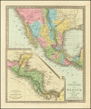
Striking full color example of Cassini's map of California, Arizona, New Mexico, part of Texas, Baja California and Mexico.
This is perhaps the only 18th Century map of the region to feature a decorative cartouche and vignette. The Rio Grande extends North to Taos & Santa Fe. The Colorado is shown, with the Gila more or less properly located. The Yuma, Cocomaricopa and Apache Indian Tribes are located, as are many settlements in Arizona and New Mexico. San Diego, Santa Catarina (Catalina), San Petro (Pedro), and the Channel Islands, are shown, along with S. Carlos (San Francisco Bay?). The Missions in Lower California, Arizona and New Mexico are shown. In Texas, Loreto, S. Antonio de Bexar, Texas, S. Sabas, S. Pablo and Loos are named, and a fair amount of the West Texas River system is shown, albeit largely conjectural.