|
||

|

|
|

|
Christopher Browne edition of Richard Daniel's map of the Northern and Mid-Atlantic British Colonies, first published in about 1679, with the original title being A Map of ye English Empire in ye Continent of America Viz. Virginia, New York, Maryland, Nw Iarsey, Carolina, New England &c.
The original Richard Daniel map and subsequent 1684 edition are very rare. It is believed to have accompanied or prepared in conjunction with a work known only in manuscript copy in the New York Public Libarry entitled The Present State of New England by Richard Daniel, Gent. This 15 page manuscript was printed in an edtion of 50 copies in 1899. The first state of the map was offered for sale by Robert Morden and William Berry. The first state is of the utmost rarity and consists of a fascinating blend of the most recent English cartographic information, described at length by Burden (#514). The first state also includes an inset map of the Carolina.
A second state of the map, published by Morden alone, was issued in about 1684 and includes significant additions, most of which appear in what would become Pennsyvlania and New Jersey.
This third state of the map, published by Christopher Browne in 1712, includes a completely revised title and a new inset map (Boston). The map celebrates the English capture of Port Royal from the French in October 1710, which was subsequently renamed Annapolis Royal, in honor of the Queen.

![[ Cape Cod to Acadia ] Pas-Kaart Vande Zee Kusten inde boght van Niew Engeland Tusschen de Staaten Hoek en C.de Sable . . .](https://storage.googleapis.com/raremaps/img/small/94453.jpg)
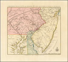
![Carte Particuliere de Virginie, Maryland, Pennsilvanie, La Nouvelle Jarsey. Orient et Occidentale [Heighten in Gold!]](https://storage.googleapis.com/raremaps/img/small/61392mp2.jpg)