


|
||

|

|
|

|
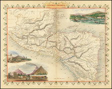
Striking view of Trujillo, Honduras, from the 1671 edition of Ogilby's America.
Trujillo or Truxillo was first founded in 1525, and remained the colonial capital of Honduras for over twelve years. It was used as the principal trade port for gold and silver mined from the Interior and bound for Spain. Like Campeche, Trujillo was a favorite target for pirates, and the city was repeatably attacked by Morgan and other infamous privateers. As a defense against the pirates, a succession of forts were built to stave off attack, but eventually Dutch pirates sacked and torched the town in 1643, and Trujillo was laid waste for one hundred and forty four years before resettlement.
This view appeared in John Ogilby's seminal atlas America: Being the Latest, and Most Accurate Description of the New World, published in London in 1671. Ogilby's work is an English translation of Arnoldus Montanus' Die Nieuwe en onbekende Weereld…, published in Amsterdam, although greatly expanded in some instances and with new maps and views. A nice dark impression.
John Ogilby (1600-1676) was an English geographer and publisher, one of the most prominent of the seventeenth century. Little is known of his early life but by 1619 he was apprenticed to John Draper, a dancing-master in London. He worked as a dancing-master, courtier, and theater owner form 1620-1641. From 1649 he worked as a poet, translator, and publisher of classical texts. It is only in the last decade of his life that he entered into geography.
In 1649, Ogilby published his first translation, of Virgil, and continued to put out translations in the 1650s and 1660s. In March 1661 he was reconfirmed as master of revels in Ireland and appointed master of the king’s imprimeries, or king’s printer. From 1662 to 1665 he was in Ireland, where he most likely met Robert Boyle. He returned to London only to lose much of his printing stock in the Great Fire of 1666. Post-fire, he became assistant surveyor to the city, where he met Robert Hooke and Christopher Wren.
In 1669, Ogilby published Embassy to China. At the same time, he planned to release atlases that would cover the entire world. These atlases would be funded via subscriptions, advertisements, and lotteries—all common practice at the time, especially for expensive multi-volume works. He released Africa and Atlas Japannensis in 1670, America in 1671 and Atlas Chinensis in 1671, and Asia in 1673. Ogilby compiled the works based on materials produced by others and they reflect a growing interest in the wider world within England.
In 1671, while producing the atlases, Ogilby secured another royal title, that of his Majesty’s cosmographer. He used this title when publishing Britannia in 1675, his best-known work. The Britannia is best described as a road atlas; it shows 2519 miles of road in 100 strip maps. This technique would be widely adopted in the subsequent century. His method of measuring with a waywiser, a large wheel, also helped to standardize the distance of the English mile at 1760 yards. The Britannia was a major achievement in early English cartography and was republished in 1698, 1719, and 1720.


![Carte Des Antilles Du Golfe Du Mexique et d'une partie des Etats voisons…1842 [Republic of Texas]](https://storage.googleapis.com/raremaps/img/small/98848.jpg)
