|
||

|

|
|

|
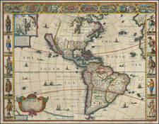
Rare separately issued map of America, published by Thomas Bakewell, issued concurrently with the Treaty of Aix-la-Chapelle, at the conclusion of the War of Jenkins Ear in America and the broader War of the Austrian Succession (1740-1748).
The map is a fascinating amalgam of various works, which Bakewell has supplemented with his own original work. The base map is drawn from the original plate for Vander Aa's map of America, which has been significantly reworked to include interesting contemporary annotations and English nomenclature, including 5 separate sections discussing contemporary Carribean trading patterns and sailing directions for ships trading in the Caribbean. A number of famous vignettes are added as side panels, including the Beaver and Codfishery scenes made famous by the maps of De Fer, Moll and Chatelain, views of the harbors of Porto Bello, Cartgena and Havana, the famous view of the Silver Mines of Potosi and other famous indigenous scenes from Florida, Virginia, Brazil, Mexico, etc. At the bottom center of the map, Bakewell adds an illustrated primer on contemporary nautical weaponry.
Bakewell's map survives in 3 recorded examples, this map being an unrecorded variant of these 3 known examples. The British Library and Colonial Williamsburg each have examples of the map only, without the side and bottom panels. The University of Michigan Clements Library holds and example of the map dated 1740, which includes the side and bottom panels. This latter example was likely issued at the outset of the war. All three surviving examples bear the date of 1740, which coincides with the celebrations of Admiral Edward Vernon's initial naval victories in the Caribbean at the beginning of the War of Jenkin's Ear. This map would appear to have been re-issued in 1748, celebrating the conclusion of the War.
Several other maps were issued in the same time period to commenorate Vernon's victory in 1749, which was widely celebrated in Britain, including a rare map of North America by Overton. A link to an example of the Overton map can be found here.
The War of Jenkins Ear commenced in late 1739. One of the first actions was the British capture of Porto Bello, a silver-exporting town on the coast of Panama in November 1739, in an attempt to damage Spain's finances and weaken its naval capabilities. The poorly defended port was attacked by six ships of the line under Admiral Edward Vernon who captured it within twenty four hours. The British occupied the town for three weeks before withdrawing, after sacking the town. The battle led the Spanish to change their trading practices. Rather than trading at centralized ports with a few large treasure fleets, they began using a larger number of smaller convoys trading at a wide variety of ports.
In Britain, the victory was greeted with much celebration, and in 1740. The conquest of a port in Spain's American empire was widely considered a foregone conclusion by many Patriot Whigs and opposition Tories who pressed a reluctant Walpole to launch larger naval expeditions. In 1740 the inhabitants of Georgia launched an overland attack on St. Augustine in Florida, supported by a British naval blockade, but were repelled. The British forces led by James Oglethorpe, the Governor of Georgia, besieged St. Augustine for two weeks before retreating, abandoning their artillery in the process. The failure of the Royal Navy blockade to prevent supplies reaching the settlement was a crucial factor in the collapse of the siege. Oglethorpe then began preparing Georgia for an anticipated Spanish assault. In 1742, the Spanish launched an attempt to seize the British colony of Georgia. Two thousands troops under the command of Manuel de Montiano landed on St. Simon's Island. General Oglethorpe rallied the local forces and defeated the Spanish regulars at Bloody Marsh and Gully Hole Creek, forcing them to withdraw. Border clashes between Florida and Georgia continued for the next few years, but there were no further offensive operations on the American mainland by either nation.
The largest action of the war was an unsuccessful attack launched by the British under Admiral Edward Vernon in March, 1741 against Cartagena de Indias, one of Spain's principal gold-trading ports in their colony of New Granada. News of the defeat at Cartagena was a significant factor in the downfall of the British Prime Minister Robert Walpole. Walpole's anti-war views were considered by the Opposition to have contributed to his poor prosecution of the war effort. The new government under Lord Wilmington wanted to shift the focus of Britain's war effort away from the Americas and into Mediterranean. Spanish policy, dictated by Elisabeth of Parma, also moved towards recovering lost Spanish possessions in Italy from the Austrians.
Several other British attacks took place in the Caribbean with little consequence on the geopolitical situation in the Atlantic. The weakened British forces under Vernon launched an attack against Cuba, landing in Guantánamo Bay with a plan to march the forty five miles to Santiago de Cuba and capture the city. Vernon again clashed with the army commander, and the expedition withdrew when faced with heavier Spanish opposition than expected. Vernon and his fleet remained in the Caribbean until October 1742, before heading back to Britain. The following year a smaller force led by Charles Knowles made raids upon the Venezuelan coast, attacking La Gauria in February 1743 and Puerto Cabello in April, though neither operation was particularly successful.