|
||

|

|
|

|
Unrecorded separately issued wall map of America, publshed by Laurie & Whittle in London.
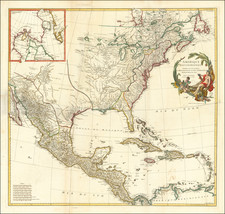
Laurie & Whittle's map of America is a highly unusual amalgam of images, bringing together a contermporary map of America with an assortment of the most famous engraved views of America from the 16th and 17th Centuries. It includes the famous Beaver and Cod Fisheries views, popularized by Herman Moll's map of the British Colonies in North America, along with a number of the images which first appeared in John White's account of Virginia, and contemporary accounts of Mexico and Peru published by Theodore De Bry.
While laid out in the style of earlier separately issued English maps of America and other parts of the world, Laurie & Whittle's map is quite different than these earlier works. Unlike the earlier works which were frequently issued to honor a significant military victory or other historical event, the present map would appear to be decorative in nature, in the style of the decorative French wall maps of the 18th Century by Clouet, Mondhare, and Brion de la Tour. It combines contemporary cartography with historical imagery and is intended to be decorative objects for the walls of a Gentleman's Library. These maps were also very popular in America among the social elite. As noted by Martin Bruckner in The Geographic Revolution in Early America. . .
British Americans frequently imported imperial maps during the eighteenth century. Decorative wall maps showing British possessions in North America were favorite articles, purchased primarily by the colonial elite. Strategically displayed in formal settings of the home or provincial office, these maps painted bombastic scenes of territorial conquest and signified the range of the British Empire.
The base map of America was originally issued by George Foster in London ca 1730 under the title A New and Correct Map of America Laid Down According to the Accurate Improvements of Senex, Moll ... Inscribed to His Royal Highness Frederick Prince of Wales. Examples of the map, show California as an island, and include a native American wearing a feathered headdress and garment, smoking a pipe, with an English soldier holding a British flag and the coat of arms of Frederick, Prince of Wales. The map also included the inset maps of Boston, the coastline of Georgia and Port Royal, along with the larger inset map of the North Pole, along wiith the Cod Fisheries scene. While the map was separately issued, it is also known to have been included in William Keith's rare History of the British Plantations in America ...., which was planned by its author as a history of the British Colonies in America, but which resulted in only a single volume, a history of Virginia, which is one of the earliest printed histories of Virginia.
In the revised map, the cartouche is completely redone, with California made as a peninsula, and the words United States engraved over the Eastern part of North America. As additional embellishment, the map adds the Beaver image made famous by Moll, and a number of scenes showing early images of the New World, including the earliest representations of Indian settlements in Virginia, images of the customs and manners of Virginians, the manner of making a Virginia canoe, a view of Mexico City, images of the customs and manners of Mexicans, and early images of Peru.
While Foster's separately issued maps of America is known in several states (all extremely rare), this state, showing California as a peninsula and with the side panels, is apparently unique. The American Philosophical Society holds the only known example of the first panelled edition of Foster's map, with Robert Sayer's imprint. This Sayer edition includes a revised cartouche and the results of the Treaty of Paris in 1763 depicted on the map. However, California is still shown as an island. In this present example of the map by Laurie & Whittle, the final changes to the map are made, making it the only known example of the map to show California as a Peninsula and including the name United States.
Robert Laurie (ca. 1755-1836) and James Whittle (1757-1818) formed their Fleet Street, London-based firm upon the 1794 death of their employer Robert Sayer, himself one of the dominant print and mapmakers of the last half of the 18th century.
Laurie & Whittle started managing Sayer's business as early as 1787. They took over all managerial duties when Sayer's health flagged in 1792, and they changed the imprint in 1794 upon his death. Sayer left the two a 21-year lease on the shop (at £100 a year) and on Sayer's Bolt Court premises, as well as an option to acquire stock and equipment at a preferential price of £5,000 payable over three years.
Robert Laurie retired from the firm in 1812, and his role was assumed by his son, Richard Holmes Laurie (1777-1858). The younger Laurie worked with James Whittle until the latter died in 1818. After R. H. Laurie died in 1858, Alexander George Findlay, FRGS (1812-1875) purchased the firm from his daughters. The firm continues today under another name, specializing in yachting charts.
Laurie & Whittle were prolific print and map publishers, and throughout their careers, they produced numerous very important and rare works. They carried on Robert Sayer's atlas business and were responsible for editions of The Complete East-India Pilot and The American Atlas.
![[ Sir Edmund Halley's Observations on the Variation of the Compass ] A New and Correct Chart of the Western and Southern Oceans Shewing the Variations of the Compass According to the latest and best Observations [with text:] The Description and Uses Of A New and Correct Sea-Chart of the Western and Southern Ocean, Shewing the Variation of the Compass](https://storage.googleapis.com/raremaps/img/small/98400.jpg)
![Tabula Terre Nove [The Admiral's Map]](https://storage.googleapis.com/raremaps/img/small/81714.jpg)