![Pascaart vertoonende de zeecusten van Chili, Peru, Hispania Nova, Nova Granada, en California…. [Early New Zealand Inset] By Hendrick Doncker](https://storage.googleapis.com/raremaps/img/small/65168.jpg)


|
||

|

|
|

|
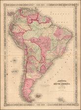
Fine Golden Age Dutch Chart with the Island of California and an Early Mapping of New Zealand
Scarce early sea chart by Doncker, showing the West Coast of the Pacific Ocean, which extends from the island of California to Chile, with noteworthy insets of New Zealand, the Ladrones, and part of Japan and Yedso.
The east-oriented chart follows the coastline closely, stopping south of La Serena in Chile. It is one of the earliest regional charts of the Pacific Coast of the Americas. This the second state of the map, which includes the Gulf Coast of Central America, unlike the first state. There are three insets nestled into inland North America and what would be the Caribbean, along with the title cartouche. These insets, outlined by delicate floral edges, show islands of interest to Europeans, although they were still seldom frequented by them when this chart was published.
California is included prominently as an island. The Canal de Santa Barbara, Monte Rey, P. Concepsion, S. Diego, Mendocino, S. Quentin, C. Blanco and many other early place names appear. Very few other islands appear in the Pacific, however.
The largest insert, in the center of the other two, shows a variety of tiny islands in the West Pacific, including the Ladrones (Marianas). These would be the first islands a navigator would meet when crossing the world’s largest ocean, making them a welcome and necessary stopover place en route to Asia. The Ladrones, or Thieves’ Islands, were so named by Magellan’s crew, who had a boat taken from them by the native Chamorros people. The crew attacked the Chamorros in return, exacting a higher price than that which had been taken.
The inset of New Zealand is a detailed treatment of Abel Tasman's discoveries in New Zealand, including five place names. Tasman had visited the island on his first voyage in the southwest Pacific, from 1642-44, the first European to do so. This is one of the earliest printed charts to give such a finely-wrought treatment of New Zealand. A more complete understanding of the islands that make up New Zealand would not be attained until Captain Cook visited the islands a century after this map was made.
The other inset shows the tip of Japan, along with three other islands, Yedso, Staten landt, and Compa[n]es Land. Also known as Yesso, is a feature included on many seventeenth and eighteenth-century maps. Historically, Ieso (Eso, Yeco, Jesso, Jeso, Yedso, Yesso) refers to the island of Hokkaido in northern Japan. It varies on maps from a small island to a near-continent sized mass that stretched from Asia to Alaska.
Nearby are two other hypothetical islands, Staten landt, and Compa[n]es Land. In the sixteenth century, Juan, the grandson of Vasco de Gama, was a Portuguese navigator who was accused of illegal trading with the Spanish in the East Indies. Gama fled and sailed from Macau to Japan in the later sixteenth century. He then struck out east, across the Pacific, and supposedly saw lands in the North Pacific.
Several voyagers sought out de Gama’s lands, including the Dutchmen Matthijs Hendrickszoon Quast in 1639 and Maarten Gerritszoon Vries in 1643. Compagnies Land, along with Staten Land, were islands sighted by Vries on his voyage. He named the island for the Dutch States General (Staten Land) and for the Dutch East India Company (VOC) (Compagnies, or Company’s Land). In reality, he had re-discovered two of the Kuril Islands. Here, Doncker has included both Staten Landt and Compag[n]es Land, separated from each other by the Straat de Vries, named for the navigator.
California as an island
One of the most striking details of this chart is the island of California. From its first portrayal on a printed map by Diego Gutiérrez, in 1562, California was shown as part of North America by mapmakers, including Gerardus Mercator and Ortelius. In the 1620s, however, it began to appear as an island in several sources.
This was most likely the result of a reading of the travel account of Sebastian Vizcaino, who had been sent north up the shore of California in 1602. A Carmelite friar who accompanied him later described the land as an island, a description first published in Juan Torquemada’s Monarquia Indiana (1613) with the island details curtailed somewhat. The friar, Fray Antonio de la Ascension, also wrote a Relacion breve of his geographic ideas around 1620. The ideas spread about New Spain and, eventually, most likely via Dutch mariners and perhaps thanks to stolen charts, to the rest of Europe.
By the 1620s, many mapmakers chose to depict the peninsula as an island. These included Henricus Hondius, who published the first atlas map to focus solely on North America with the island prominently featured in 1636. Hondius borrowed his outline of California from another widely-distributed map, that of Henry Briggs and printed in Samuel Purchas’ Hakluytus Posthumus or Purchas his Pilgrimes (1625).
Other prominent practitioners like John Speed and Nicolas Sanson also adopted the new island and the practice became commonplace. Indeed, this map’s California is based on a Sanson map of 1656.
Father Eusebio Kino initially followed along with this theory, but after extensive travels in what is now California, Arizona, and northern Mexico, he concluded that the island was actually a peninsula. Even after Kino published a map based on his travels refuting the claim (Paris, 1705), California as an island remained a fixture until the mid-eighteenth century, as this map illustrates.
This fine chart illustrates a seldom seen world, as the Pacific was still seldom traversed by Europeans at this time. It is not often seen on the market.
Hendrik Doncker was a prominent bookseller in Amsterdam best known for his sea charts and nautical atlases. He issued his own original charts, which he updated frequently, and also worked with colleagues like Pieter Goos, for example to produce the pilot guide, De Zeespeigel. He died in 1699, after fifty years in business. His plates then passed to Johannes van Keulen.
![California [early appearance of Orange County!]](https://storage.googleapis.com/raremaps/img/small/96829.jpg)
![Neu-Seeland [with] West Australien [with] Tasmania](https://storage.googleapis.com/raremaps/img/small/98073.jpg)