


|
||

|

|
|

|
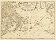
Rare Dutch edition of Muller's rare map of 1754, showing the Russian discoveries in the Northwest part of America.
Streeter notes that
This...map confirmed the existance of a body of water between Asia and America, the subject of much dispute during the previous two hundred years. It also showed the Kurile Islands correctly and suggested the outline of Alaska and the Aelutian chain. Though the Russian discoveries had been shown on the Delisle map...published in 1752...this is the first map to give an approximate picture of what is now the Alaska peninsula.… The present map is copied from the 1758 issue, with the word Russes in the Title changed to Russiens.and the 1758 date given in the title cartouche; in the lower margins is the Amsterdam imprint and 1766 date and L. Schenck, Jansz: Sculpsit 1765.
Wagner notes that the map seems to be the earliest to show the discoveries of Bering and Chirikof in 1741 with the tracks of the vessels in the north Pacific..." Wagner 591.
The map appeared in the Dutch edition of Muller's Voyages et decouvertes par les Russes le long des cotes de la mer glaciale & sur l'ocean oriental.... Muller compiled a highly influential study of Russian explorations in the North Pacific,in which he includes a remarkable compilation of source information from the Russia's Great Northern Expedition. The work provides an excellent acocunt of the expeditions of Vitus Bering and Aleksei Chirikov along the Alaskan coast, as well as information gathered by Martin Spanberg, who was "sent in command of three small, hastily built ships to sail south and untangle the geography of the Kuril Islands and Hokkaido, Japan. During three voyages Spanberg and Walton, his lieutenant, successfully mapped the Kurils and sailed coastal Japan" -- Nebenzahl.
Muller's map represents a meticulous synthesis of the information provided by the early Russian explorers. This edition of Muller' influential map bears the imprint of Marc Michel Rey and was "extensively copied by others" -- Tooley. Nebenzahl writes, "shortly after the De L'Isle-Buache map appeared, Muller published his greatly improved delineation of the area that disposed of the ficticious landmasses north and east of Japan and indicated the Russian discoveries in Alaska... Muller clearly shows the routes of Bering and Chirikov and the regions of the Alaskan coast that each explored." Muller's volume became the standard authority on the Pacific Northwest. This first French edition is "fuller and quite superior to the English translation published by Jefferys in 1761" -- Streeter. It was this edition that was purchased by Thomas Jefferson for his library at Monticello. Thirty-seven years after its publication, Jefferson would dispatch Meriwether Lewis and William Clark on an overland expedition to establish the United States' claim to the Northwest.

![Tabula Geographica Hemisphaerii Borealis ad emenatiora quae adhuc prodieruntexampla jusqu Acad. Reg. Scient. et Eleg. Litt. Boruss. descripta [with:] Tabula Geographica Hemisphaerii Australis...](https://storage.googleapis.com/raremaps/img/small/81806.jpg)
