|
||

|

|
|

|
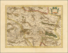
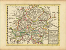
Scarce map of the Theater of War in Austria, between Pressburg and Passau, centered on the course of the Danube.
The map covers the Theater of War for the Austro-Bavarian War (1741-45) one of the wars which comprise the War of Austrian Succession.
Following the death of Charles VI, his Daughter Maria Theresia struggled to retain Hapsburg power over the Empire. Duke Charles-Albert of Bavaria contended for the Imperial crown and was elected Emperor in 1742. In 1741, Bavarian troops occupied the region depicted in the map. The occupation spread to Bohemia in 1742, where Charles-Albert had himself crowned King of Bohemia. Following a secret treaty of alliance with France and Spain, Bavaria was supported by French troops.
Maria Theresia went to Pressburg, then the Hungarian capital. There she addressed the Hungarian nobility, attemping to rally support. The Hungarian nobility pledged to support her. Austrian forces then went on to expel the Franco-Bavarian troops from Upper Austria and Bohemia, later occupying Bavaria. By the end of 1742, Bavaria had been knocked out of the war in 1742.
George-Louis Le Rouge (1712-1790), though known for his work in Paris, was originally born Georg Ludwig of Hanover, Germany. He grew up and was educated in Hanover, after which he became a surveyor and military engineer. Around 1740, however, Le Rouge moved to Paris and set up shop as an engraver and publisher on the Rue des Grands Augustins. It was at this time that he changed his name, adopting a French pseudonym that would later become quite famous.
Le Rouge spent much of his forty-year career translating various works from English to French, and his cartographic influence often came from English maps. His experience as a surveyor and engineer in Germany made him a skilled and prolific cartographer, and he produced thousands of charts, maps, atlases, and plans. His work spans from garden views and small-town plans to huge, multiple-continent maps. Le Rouge eventually accepted the position of Geographical Engineer for Louid XV, the King of France.
Later in life, Le Rouge became well-known for publishing North American maps, such as in his Atlas ameriquain septentrional of 1778. One of Le Rouge’s other more famous works is the Franklin/Folger chart of the Gulf Stream, which he worked on with Benjamin Franklin. Franklin and Le Rouge corresponded around 1780 and collaborated to create this map, a French version of Franklin’s famous chart which was originally printed in 1769.
![[ Innsbruck ] Oenipons Sive Enipontiis Vulgo Inspruck. . .](https://storage.googleapis.com/raremaps/img/small/89304.jpg)