![Africa / Lybia / Morland / mit allen kunigsreichen so zu unsern zeiten darin gefunden werden [Afrika/Libyen/Morenland, with all the kingdoms found therein in our time] By Sebastian Munster](https://storage.googleapis.com/raremaps/img/small/95771.jpg)


|
||

|

|
|

|
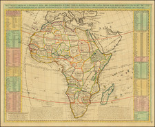
Munster's map of Africa is the earliest obtainable map of the continent.
The map is also rich in mythical content, adorned with a cyclops, ship, and an elephant. The Kingdom of Prester John is also indicated. The map is based in part on the work of Ptolemy, partly on Portuguese and Arabic sources. Zaphala Aurifodina of Portuguese origin is the supposed region from which King Solomon imported his gold and silver. Quiloa and Melinda were Arab settlements. It also shows Hamarich, Prester John's capita city.The Cape of Good Hope is marked, and the Nile flows into the Mountains of the Moon, south of which the country (the Cape) is said to be uninhabited. Crowns and sceptres indicate kingdoms; and parrots, elephant and a Cyclops illustrate its western shores, with a fine galleon in full sail to the left of the Cape of Good Hope.
The map is unchanged from the 1540 edition. Munster's Geographia was a cartographic landmark, including the first separate maps of the 4 continents and the first map of England and the earliest obtainable map of Scandinavia. Munster dominated cartographic publication during the mid-16th Century. Munster is generally regarded as one of the most important map makers of the 16th Century. The information for the Geographia was compiled from scholars around the Europe in the 1530s and included the most up to date information. A fine dark impression of this first state.
Sebastian Münster (1488-1552) was a cosmographer and professor of Hebrew who taught at Tübingen, Heidelberg, and Basel. He settled in the latter in 1529 and died there, of plague, in 1552. Münster made himself the center of a large network of scholars from whom he obtained geographic descriptions, maps, and directions.
As a young man, Münster joined the Franciscan order, in which he became a priest. He then studied geography at Tübingen, graduating in 1518. He moved to Basel, where he published a Hebrew grammar, one of the first books in Hebrew published in Germany. In 1521 Münster moved again, to Heidelberg, where he continued to publish Hebrew texts and the first German-produced books in Aramaic. After converting to Protestantism in 1529, he took over the chair of Hebrew at Basel, where he published his main Hebrew work, a two-volume Old Testament with a Latin translation.
Münster published his first known map, a map of Germany, in 1525. Three years later, he released a treatise on sundials. In 1540, he published Geographia universalis vetus et nova, an updated edition of Ptolemy’s Geographia. In addition to the Ptolemaic maps, Münster added 21 modern maps. One of Münster’s innovations was to include one map for each continent, a concept that would influence Ortelius and other early atlas makers. The Geographia was reprinted in 1542, 1545, and 1552.
He is best known for his Cosmographia universalis, first published in 1544 and released in at least 35 editions by 1628. It was the first German-language description of the world and contained 471 woodcuts and 26 maps over six volumes. Many of the maps were taken from the Geographia and modified over time. The Cosmographia was widely used in the sixteenth and seventeenth centuries. The text, woodcuts, and maps all influenced geographical thought for generations.
![[ Ancient World ] Christianographie](https://storage.googleapis.com/raremaps/img/small/80305.jpg)
![[Africa] (2 maps - Ancient & Modern)](https://storage.googleapis.com/raremaps/img/small/70579.jpg)