|
||

|

|
|

|
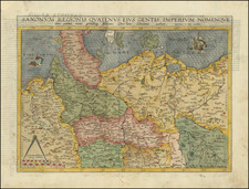
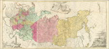
Rare 2 sheet map showing the Russo-Turkish Theater of War.
The Russo-Turkish War of 1710-1713 started after the Russians had defeated the Swedes in the Battle of Poltava. With the help from Austrian and French diplomats, Charles XII of Sweden managed to persuade the Turkish Sultan to declare war on Russia on November 20, 1710. The principal event of this war was the Prut campaign of 1711, which would turn out to be unsuccessful for Russia.
The present map would appear to have been prepared in 1711, using the eastern 2 sheets of Nolin's 4 sheet map of Europe. A section in the lower left corner of the lower sheet was masked off and a second plate used to engrave a special title for the map. The map is apparently very rare. We have been unable to locate any other example of the map.
Jean-Baptiste Nolin (ca. 1657-1708) was a French engraver who worked at the turn of the eighteenth century. Initially trained by Francois de Poilly, his artistic skills caught the eye of Vincenzo Coronelli when the latter was working in France. Coronelli encouraged the young Nolin to engrave his own maps, which he began to do.
Whereas Nolin was a skilled engraver, he was not an original geographer. He also had a flair for business, adopting monikers like the Geographer to the Duke of Orelans and Engerver to King XIV. He, like many of his contemporaries, borrowed liberally from existing maps. In Nolin’s case, he depended especially on the works of Coronelli and Jean-Nicholas de Tralage, the Sieur de Tillemon. This practice eventually caught Nolin in one of the largest geography scandals of the eighteenth century.
In 1700, Nolin published a large world map which was seen by Claude Delisle, father of the premier mapmaker of his age, Guillaume Delisle. Claude recognized Nolin’s map as being based in part on his son’s work. Guillaume had been working on a manuscript globe for Louis Boucherat, the chancellor of France, with exclusive information about the shape of California and the mouth of the Mississippi River. This information was printed on Nolin’s map. The court ruled in the Delisles’ favor after six years. Nolin had to stop producing that map, but he continued to make others.
Calling Nolin a plagiarist is unfair, as he was engaged in a practice that practically every geographer adopted at the time. Sources were few and copyright laws weak or nonexistent. Nolin’s maps are engraved with considerable skill and are aesthetically engaging.
Nolin’s son, also Jean-Baptiste (1686-1762), continued his father’s business.
![[ Aegean Sea ] Das Aegaeische Meer Heute der Archipelagus oder das Insel=Meer Nro. 18](https://storage.googleapis.com/raremaps/img/small/102204.jpg)