


|
||

|

|
|

|
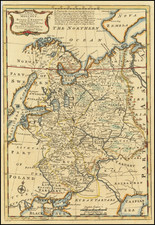
Fine example of Moses Pitt's map of Ukraine, divided into provinces, from Pitt's ill-fated attempt to continue and expand upon the Atlas Maior published by Jan Jansson.
Pitt's map, first issued by Jan Jansson in about 1657, is one of the earliest maps to include the name Ukraine in the title of a printed map, following shortly after the Treaty of Zboriv in 1649, although derived largely from Beauplan's maps.
The name Ukraine was popularized in the west by Guillaume La Vasseur de Beauplan's Description d'Ukraine, first published in Rouen in 1651 (in an edition of 100 copies) under a different title, with the named changed as above in the 1660 edition and subsequent editions published in French (1661, 1662, 1663) Latin (1662), Dutch (1664), Spanish (1665 and 1672) and English (1680). The work described Ukraine as several provinces of the Kingdom of Poland lying between the borders of Muscovy and the frontiers of Transylvania.
Beauplan, a military engineer, had spent a significant period of time constructing fortresses in the region in the 1630s. In 1650, his map entitled Delineatio Specialis et Accurata Ukrainae, showed the palatinates of Kyiv, Bratslav, Podilia, Volhynia and part of Rus (Pokutia). Another of Beauplan's maps, published in 1648, entitled Delineatio Generalis Camporum Desortum vulgo Ukraina, Cum adjacentibus Provinciis, shows all of the provinces of Poland bordering on the Campus Desertorum or steppe frontier, thereby recognizing the Russian and Polish language references to Ukraine as the "steppe frontier" and leading to the popularization of the name in Western Europe.
The region was later defined by the Zboriv Treaty of 1649, which did not include Rus or Volhnia, but did include Chernihiv. This treaty established the Cossack control of the regions and severed Poland's claims and created the region which would come to be known in the west as the Ukraine.
Pitt was from Cornwall, where he was baptized at St. Teath in 1639. He was educated locally but moved to London when apprenticed to bookseller Robert Littlebury. At the end of his apprenticeship, in 1661, he was made free of the Haberdasher’s Company. His first books to be published with his own imprint appeared in 1667.
Pitt specialized in learned publications and imported scholarly works from continental Europe. He also published the writings of members of the newly formed Royal Society, including Robert Boyle, as well as high-ranking clergymen. In 1678, Pitt was the first bookseller to offer his wares via an auction.
Thanks in part to his ties to the Royal Society, Pitt announced in 1678 that he would publish a massive twelve-volume atlas of the world. The plates were to be based on Dutch maps, with a text written by Bishop William Nicholson and Richard Peers. However, only four volumes ever appeared.
Pitt, who was also managing several properties in Westminster and had expanded in a partnership to Oxford, was spread too thin. The cost of each volume of the atlas alone Pitt estimated at £1,000. One by one, his ventures turned foul, landing him in debtors’ prison for seven years. He died in London, but not in prison, in 1697.
![(Second World War - The Eastern Front) [Hungarian Air Navigation Map of Ukraine]](https://storage.googleapis.com/raremaps/img/small/90095.jpg)
![[ Jan Mayen Island ] Isola Di Mayen Scoperta l'Anno 1614 . . .](https://storage.googleapis.com/raremaps/img/small/99105.jpg)