


|
||

|

|
|

|
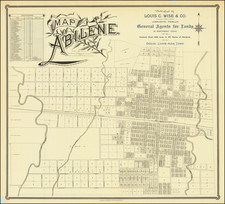
Flawless uncirculated example of this rare map of Abilene Texas, drawn by A.H. Kirby and compiled by J.A. Thomas, County Surveyor, quite likely the earliest printed map of the city. Printed by Clarke & Courts of Galveston, Texas.
Highly detailed cadastral map, showing land lots, creeks, and Texas & Pacific Railroad. Includes index to subdivisions. The map notes that it is "Published by Louis C. Wise & Co. (successors to Holt & Wise) general agents for lands in Northwest Texas. Control over 500 lots in all parts of Abilene. Choice lands near town." Dozens of land owners are identified, along with street names, public buildings, and other information.
By the 1870s, the Indians had been driven out of the area and cattlemen began to graze their herds in the area. Taylor County was organized in 1878, and Buffalo Gap was designated the county seat. When the Texas & Pacific Railway began to push westward in 1880, several ranchers and businessmen, including Claiborne W. Merchant, John Merchant, John N. Simpson, John T. Berry, and S. L. Chalk, met with H. C. Whithers, the Texas & Pacific track and townsite locator, and arranged to have the railroad bypass Buffalo Gap. They agreed that the route would traverse lands which the group owned in the northern part of the county, and that a new town would be established between Cedar and Big Elm creeks east of Catclaw Creek. C. W. Merchant apparently suggested the name Abilene, after the Kansas cattle town.
After the Texas and Pacific arrived at the site in January 1881 the railroad promoted Abilene as the "Future Great City of West Texas." J. Stoddard Johnston and other railroad officials platted the townsite. Several hundred people arrived in Abilene before the sale of town lots and began to establish businesses and a church. The lots were auctioned on March 15, 1881; in two days buyers purchased more than 300 lots, and Abilene was officially established. On January 2, 1883, the residents voted to incorporate, and in an election held on October 23, 1883, Abilene became the county seat. By 1890 the city had a population of 3,194; twenty years later the number of residents was 9,204.
Major Louis C. Wise was one of the earliest residents of Abilene. In fact he visited the area before the town was established and when it was founded he returned. Following the close of the war, Wise went to Mexico as an engineer on the survey of the Vera Cruz and Mexico Railroad. He then came to Texas in 1866, settling first at Bastrop, where he engaged in teaching school. He was afterward employed as a draftsman in the state land office, at Austin. In 1880, he resigned that position and went on a land surveying expedition for the Houston & Great Northern Railroad Company, visiting northwest Texas, principally the counties of Dickens, Crosby, Kent and Garza. In 1880 and 1881, he returned relocated to Abilene, with the exception of a period of eight years when he was appointed as chief draftsman at the land office at Austin.
The map was published by Clarke & Courts, on what is believed to be the oldest lithographic printing press in the State of Texas. Clarke and Courts traces its roots to M. Strickland and Company, organized at Galveston by Miles Strickland in 1857. Strickland moved his printing press to Houston, but subsequently returned to Galveston. Robert Clarke became a partner in the firm in 1870. In 1877, George M. Courts purchased Strickland's interest. In 1877, the two printers brought the first lithograph press in the state to Galveston.
OCLC locates 3 examples (Yale, SMU, Hardin-Simmons).

![(Mexican War) [ Proposed United States - Mexico Military Border - January 1848 ]](https://storage.googleapis.com/raremaps/img/small/99246.jpg)
