|
||

|

|
|

|
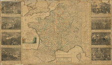
Separately issued 2 sheet map of the region from Val D'Aouste to the French & Italian Riviera, from Monaco and Nice northward to Savona. Inset map of the environs of Nice.
Rare separately issued regional map, in an original slip case, based in part on the Du Val/Placide map of 1691. The present example retains the Renard imprint information in the lower sheet at the left, pre-dating the more common editions published by Covens & Mortier. The map more commonly appeared as two maps in atlases published by De L"Isle and Ottens, the first bearing the title Carte du Piemont et du Monferrat. . . . and the second Partie Meridionale du PIemont et du Monferrat . . . The present example bears De L'Isle's privildge in the title.
A fine full color example, with original linen backing and original slip case.
Guillaume De L'Isle (1675-1726) is probably the greatest figure in French cartography. Having learned geography from his father Claude, by the age of eight or nine he could draw maps to demonstrate ancient history. He studied mathematics and astronomy under Cassini, from whom he received a superb grounding in scientific cartography—the hallmark of his work. His first atlas was published in ca. 1700. In 1702 he was elected a member of the Academie Royale des Sciences and in 1718 he became Premier Geographe du Roi.
De L'Isle's work was important as marking a transition from the maps of the Dutch school, which were highly decorative and artistically-orientated, to a more scientific approach. He reduced the importance given to the decorative elements in maps, and emphasized the scientific base on which they were constructed. His maps of the newly explored parts of the world reflect the most up-to-date information available and did not contain fanciful detail in the absence of solid information. It can be fairly said that he was truly the father of the modern school of cartography at the commercial level.
De L’Isle also played a prominent part in the recalculation of latitude and longitude, based on the most recent celestial observations. His major contribution was in collating and incorporating this latitudinal and longitudinal information in his maps, setting a new standard of accuracy, quickly followed by many of his contemporaries. Guillaume De L’Isle’s work was widely copied by other mapmakers of the period, including Chatelain, Covens & Mortier, and Albrizzi.
![Gallia Narbonens [on sheet with] Savaudiae Ducat. [on sheet with] Venuxini Comitatus Descr.](https://storage.googleapis.com/raremaps/img/small/61471.jpg)