


|
||

|

|
|

|
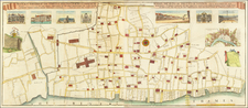
Rare (unrecorded?) plan of the burned portion of London, based upon Robert Hooke's plan to rebuild the burned areas, including a new waterfront road, bridge, fountains, bridge, etc. Streets named include Strand and Holbourne.
The map is similar to two inset maps we have identified from contemporary plans of London. The first is Marcus Willemsz Doorink's PLATTE GRONDT der Verbrande Stadt LONDON . . . published in Amsterdam, which includes an inset map entitled NIEUW MODELL om de afgebrande Stadt LONDON te HERBOUWEN (Howgego 60). The second is Jacob Venckel's broadside map showing the Great Fire of London, which includes the same title as Doorink's map and the same insets (Howgego 24).
The inset map depicts Hooke's plan to rebuild the City. The major difference between the present map and the 2 above referenced maps is that the present example is larger and covers a larger area than Doorink and Venckel insets.
This map would seem to be a fragment from a larger map, but we have been unable to locate the original map. The fragment was found on the back of a 1666 De Wit Broadside fire plan of London.
![[London / Tower of London ] La tour de Londres](https://storage.googleapis.com/raremaps/img/small/101674.jpg)
![Regionis, quae est circa Londinum specialis repraesentatio geographica, ex autographo majori Londinensi . . . 1741 [Includes Bird's-eye View of London and Westminster]](https://storage.googleapis.com/raremaps/img/small/95041.jpg)
![Londinum Urbs Praecipua Regni Angliae [London, the Principal City of the Kingdom of England.]](https://storage.googleapis.com/raremaps/img/small/93684.jpg)