This item has been sold, but you can enter your email address to be notified if another example becomes available.


|
||

|

|
|

|
Stock# 21991
Description
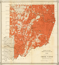
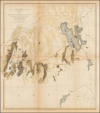
Detailed map of Indian Territory, during the short-lived period where Oklahoma was divided into two Territories, Oklahoma Territory and Indian Territory.
Nice large format treatment of the wilderness area of eastern Oklahoma, showing towns, railroads, roads, rivers, forrest areas and nice depiction of the topography of the region. From the Twenty-First Annual Report of the United States Geological Survey. Part V. Pl.142.
Condition Description
Minor fold splits, reinforced on verso.
![Mexique par Th. Duvotenay…1842 [Republic of Texas]](https://storage.googleapis.com/raremaps/img/small/93713.jpg)